urbanism – landscape – ideas – theory – whimsy

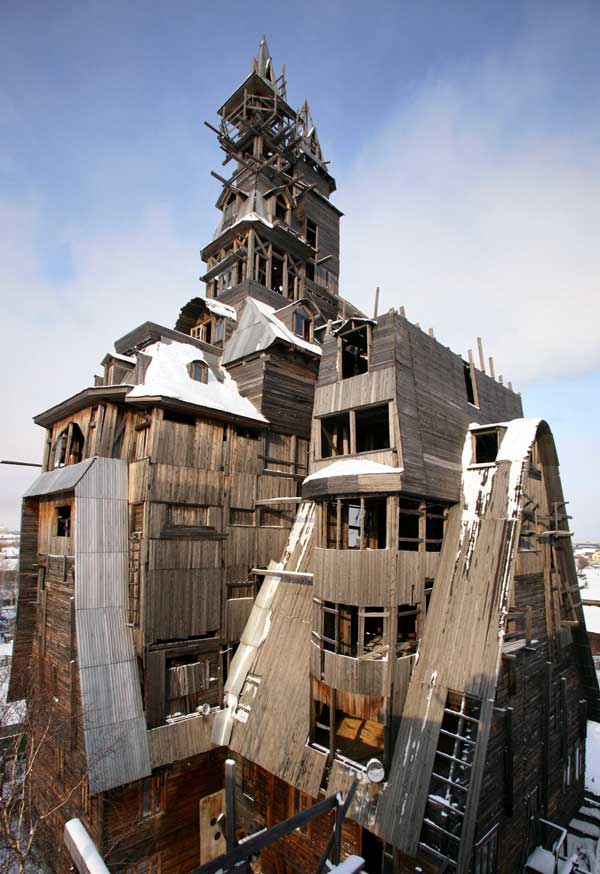
World’s tallest wooden house

tallest-wooden-house_e.jpg

A friend just sent this around, and what a doozy! Props to Gaston!

Sutyagin House, Arkhangelsk, Russia

This imposing building is believed to be the world’s tallest wooden house rising 13 floors to reach 144ft. The house is also crumbling, incomplete and under threat of demolition from city authorities who are eager to end Nikolai Sutyagin’s 15 year project. Driven to inspiration by his formative years spent in a Soviet communal flat, Sutyagin felt lonely living by himself. Building began in 1992 and was only going to reach two stories high, however, convinced by a trip to see wooden houses in Japan and Norway, he decided he had not used enough roof space efficiently enough and decided to keep building. He firstly added three floors, but was not keen on the outcome, so he added more floors and just kept goind, he calls the finished project a “happy accident”. For the one-time gangster, who has spent four years in jail on racketeering charges, Nikolai Sutyagin’s home is certainly different. Not only would his house be a perfect love nest, but it could even accommodate the 18 executives of his construction company. Now penniless Sutyagin lives in four poorly heated rooms at the bottom of his wooden log cabin with his wife. Many neighbours consider the building a monstrosity, others feel it is a glorified barn, fire hazard and eyesore but Sutyagin is determined to save his building and has erected a roof around the second floor that he says allows him to claim that everything above is decoration.

Note the lookout tower for those pesky planners

Favela Japonesa

un11214934gf-sm.jpg

A friend’s Portuguese cousin sent these awesome images to him and he duly forwarded them to me. The title really says it all: Favela Japonesa indeed! Of course, perhaps a more flexible usage of the concept is required than the english equivalents shantytown/slum – my mind’s drawing a blank, but in spanish, the word barrio, while carrying the same connotations (particularly in Venezuela), also simply means district or neighbourhood. Whatever the word should be, we like where this idea is headed… for something mildly related, don’t forget to check out the Personal Container Management post from November, and to see 50 selected projects utilizing shipping containers try fabprefab.com.

Addendum (May 2010): a commenter indicates that this is actually a Dutch student housing project at the University of Utrecht called Spacebox – 300 units have been built

un21533268qr-sm.jpg

un32471248ch-sm.jpg

un43016825tw-sm.jpg

un53028353hq-sm.jpg

un01210319eh-sm.jpg

GTA population grows by 9.2% since 2001

statcan_toronto_cma.jpg

Statistics Canada has started to release data from the 2006 census at the City level – including population figures for Toronto and the GTA (or at least the Toronto Census Metropolitan Area (CMA), mapped above). By this measure, the GTA has grown 9.2% since 2001, with a population of 5,113,149 – that’s an increase in population of 430,252 in five years. The City of Toronto itself accounted for only 21,787 of this increase (with a very modest growth rate of 0.9%, and despite what most of us would think of as a significant high-density condo boom) which gives you an idea of the massive pressure on land development at the edges of the city.

To put that in perspective, the increase is equivalent to adding the entire Kitchener CMA (which includes Kitchener-Waterloo and Cambridge)(451,235), or the entire London (ON) CMA (457,720) to the GTA in the last five years. That’s very nearly the entire population of Newfoundland and Labrador (505,469), and eerily near the population of the City (not CMA) of Vancouver (578,041).

This only emphasizes the critical importance of GTA-wide planning along the lines of the Places to Grow work being done by the Province, but also makes one wonder where this type of planning was 10 or 20 years ago when we really needed it. If this kind of growth keeps up, the Provincial target to have 40% of new residential units inside the current urban boundaries is going to be a real challenge.

Relax…

PLANT wins Nathan Phillips Square competition

Plant Architect & Shore Tilbe Irwin were announced the winner of the Nathan Phillips Square competition. For more information on the competing schemes see the Spacing Wire post or the City of Toronto’s website.

The rest of the team members were:

  • Peter Lindsay Schaudt Landscape Architecture, Inc. (landscape design collaborator, Chicago)
  • Adrian Blackwell (urban design collaborator and art consultant, Toronto)
  • Blackwell Bowick Partnership Limited (structural engineering, Toronto)
  • Blanche Lemko van Ginkel (historical guidance, Toronto)
  • Crossey Engineering Ltd. (integrated mechanical and lighting systems design, Toronto)
  • Enermodal Engineering Limited (environmental and sustainability design and integration, Kitchener, Ontario)
  • Theatre Projects Consultants (theatre consultant, S. Norwalk, Connecticut)
  • Vermeulens Inc. (quantity surveying, Richmond Hill, Ontario)

Spadina Subway Extension Clears Funding Hurdle

The Toronto Star is announcing on its front page that a final $697 million from the federal government has sealed the Spadina Subway Extension deal (see their article here). The money comes as part of a large package of funding for transit in the GTA including:

A Mississauga transitway, a bus-only road along Highway 403 and Eastgate Parkway from Burnhamthorpe Rd. to Eglinton Ave. E.

Brampton’s $280-million Acceleride project, meant to speed bus service. Ontario has already committed $95 million for the improvements.

An expansion of York Region’s Viva bus system. York Region officials want to get buses on to dedicated lanes.

The widening of Highway 7, in the amount of $55 million.

An environmental assessment to extend Highway 407 eastward to link up with Highway 401. This would go through federal Finance Minister Jim Flaherty’s Whitby-Oshawa riding.

A $5 million study of rapid transit in Durham.

For those unfamiliar with the $2 billion Spadina Extension proposal, it continues the Spadina subway line north to York University, then beyond Toronto’s boundary at Steeles to connect to (the future) Vaughan Corporate Centre at Highway 7 in Vaughan. I include a map below from the TTC’s website on the matter – more information can be had here.

preferaligapril_e.jpg

Lower Don Vision – bricoleurbanism style

lowerdon_bricoleurbanismorg_crop2.jpg

The TWRC recently put out a call to Torontonians for visions for the Lower Don Lands and the mouth of the Don River (see here), perhaps as a consolation for the closed, restrictive process they seem intent on following for their “Innovative Design Competition for Toronto’s Lower Don Lands” for which they released a shortlist on 2 February (see here).

Maybe they thought that the Innovative Design Competition for the Central Waterfront (see here) was so successful, they figured they’d just do the same thing over again. At least it’s clear that they’re intent on moving forward with winning schemes into implementation, which is not always the case.

But starting off with an RFP process is hardly a way to get the maximum number of people involved. While they say that they’re “seeking input from the world’s most talented and creative design and engineering professionals in developing bold new concepts for the Lower Don Lands area”, it hardly seems likely that the world’s most talented and creative people have been boiled down to the 5 shortlisted teams. The proposals themselves are never released publicly, only the finalists’ entries are, so at best we get 5 concepts to publicly review and have to rely on the wisdom of the shortlisting process to have chosen teams that might produce the most innovative design responses.

While the process obviously can work (quite a bit of attention was generated with the Central Waterfront competition), it does have drawbacks – the winning team for the Central Waterfront (West8/DTAH) was a clear winner since most people were less than impressed by the other teams’ submissions. The fact that the Nathan Phillips Square competition (see here) is being run in the same way, makes it clear that a wide spectrum of ideas is not what public agencies in Toronto are really after.

Which leaves some designers and Torontonians (either those not shortlisted, or ineligible to compete by virtue of not being on a team with all the requirements demanded by the RFP) shit out of luck. Cue the “Submit Your Vision for Toronto’s Lower Don Lands”. However, being limited to a single double-sided letter sized page is certainly unusual for most designers, so it’s obvious that they really are looking for the ideas of the average Torontonian.

And as for design students, who traditionally are keen submitters to competitions (if only because their studios are often based on a current competition), whatever ideas they may have come up with, they’d better fit on that double-sided page too.

So, even if only to get the ball rolling and get some ideas out in public (where’s the TWRC going to hide all the visions submitted by Joe Public?), bricoleurbanism.org is proud to here present our vision for the Lower Don Lands. Click on the images to view the full drawings.

lowerdon_bricoleurbanismorg_crop4.jpg

Mapping Our Urbanism Part III – Water Mains

to_watermains_early2_e.jpg

In the Toronto Star last weekend was a special 2-page spread on the sorry state of Toronto’s water mains with emphasis on who’s to pay for upgrades (see story online here). However, the maps included give a fascinating glimpse into the history of Toronto’s development seen through the age of the water mains. Divided into four periods, 1859-1900, 1901-1940, 1941-1960, and 1961-2000, these maps are indispensable for anyone interested in the history of urban infrastructure. To see a little more detail, follow these links (maps 1+2, maps 3+4) – if you prefer a much more detailed PDF version of the maps is available from the Star’s site here (PDF).

to_watermains_modern2_e.jpg

Crossposted to the Spacing Wire

Planning in Ontario – Part I: The OMB

With all the bad blood that the Queen West Triangle planning and OMB extravaganza has created in Toronto (see Active 18, spacingwire posts here, Reading Toronto here), it’s worth reflecting on the true nature of planning in Ontario.

Anyone familiar with the Ontario Municipal Board (OMB) process will know that the “Board” is in fact essentially a kind of court (dare we say kangaroo court?), where land use planning disputes are frequently heard when someone doesn’t like the decision made by the municipal planners or politicians. The process really boils down to lawyers arguing before a judge, using “experts” from the professions as both hired witnesses and fabricators of “evidence”. Anyone who thinks that that sounds a little strange must be new to the bizarre world of planning in Ontario.

In the spirit of openness that our planning system should be engendering, let’s get some help from Ambrose Bierce’s wonderful century-old Devil’s Dictionary for some enlightenment on the process (an online version of the dictionary is wideley available as copyright has expired, try here).

Bierce defined a lawyer as:

LAWYER, n. One skilled in circumvention of the law.

Who better to be in control of key planning decisions in Ontario?

But wait, there’s more!

The profession of planning in Ontario seems to be held in such poor esteem by the populace that despite widespread disgust with the OMB and its (perceived) pro-development decisions, there seems to be minimal support for planners having any more control over planning either! Who needs those silly professions after all?

Luckily, Bierce can help us out again to clarify what planners are trying to do in the first place.

Bierce defined to plan as:

PLAN, v.t. To bother about the best method of accomplishing an accidental result.

Sound familiar?

We might go so far as to say that such a definition of plan largely applies to public planning in this province. Private (consulting) planning might be better represented by an amalgam of the two thusly:

PLANNER (PRIVATE), n. One skilled in circumvention of the plan.

Enough said! Lesson 1 of a 106 part series, “Planning in Ontario”!

“Paving” the way for a new Four Seasons

yorkville-bay-pan-f_e.jpg

A rough timelapse sequence of the demolition of the old Ford dealership on Yorkville Avenue as part of site preparations for the new Four Seasons hotel/condominium proposal which will stretch from the historic fire station (with the tower visible in the photos) west between Yorkville Avenue and Scollard Avenue to Bay Street. The yellow box in the left of the photos is the sales centre (under construction).

The proposal is for two towers, one 46 storeys at the corner of Bay and Yorkville and the other of 30 storeys on Scollard adjacent to the existing recently completed mid-rise residential building. The proposal also includes a new urban square/park to complement the one built to the east of the fire hall and Yorkville library as part of the 18 Yorkville development, along with an integrated linear connection joining the two parks behind the library and fire hall. While these drawings certainly don’t show that the new park at this point will have the panache of the one designed by JRALA, the proposal has been given City approval, but I believe it has been challenged at the OMB by community and residents groups, with a decision still to come. More info (from the City) can be found here, OMB case details here and here.

Despite the enormous amounts of money involved in such large scale developments, it’s a sobering thought that surface parking is so profitable that it’s the first thing you do while waiting for your official go-ahead.

4s_4_birdsey_view_e.jpg

4s_courtyard2_lg_e.jpg

4s_dusk_lg_e.jpg