urbanism – landscape – ideas – theory – whimsy

Tahrir Square, Cairo – From Traffic Circle to Civic Square

Annotated photo from BBC (over Reuters photo) of Tahrir Square, Cairo at the height of the protests (click through to BBC to read the annotations

Tahrir Square in central Cairo became the nucleus for unprecedented protests against the government in Egypt in February. While the name Tahrir means Liberation (referring to the Egyptian revolution against British rule in 1919, but subsequently co-opted to also refer to the 1952 military coup that removed the Egyptian monarchy and established the modern Republic), the space itself normally hardly serves as a great civic square, being for all intents and purposes a huge traffic circle.

Tahrir Square area from Google Maps

But it just goes to show that the utility of a civic square lies as much in its imagined symbolic role as in its intended programme and design – the key requirement is largely that the space is simply open. It doesn’t matter if it’s legally accessible, or if the law allows peaceful assembly. In times of crisis or great importance, people will gather in the place that captures the public imagination. After all, traffic is certainly no obstacle to a revolution.

Tahrir Square - Daily Mail (Associate Press) photo

Tahrir Square on Friday of Departure (Feb 4th) by Flickr user Mona Sosh

Crowds in Tarhrir Square (Photo: AP/Tara Todras-Whitehill)

Friday prayers by the Tahrir Square demonstrators, photo by Amr Addullah Dalsh (Reuters via Calgary Herald)

Toronto’s inner-city/inner-suburb political divide continues

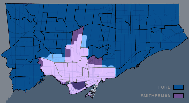
2010 Toronto Mayoral Election results by ward (by Marc Lostracco/Torontoist.com), move over with mouse to superimpose Old City of Toronto boundaries

In what one commenter called Mike Harris’ gift that keeps on giving (or rather, the pain that keeps on hurting), Toronto’s 12 year-old forced amalgamation continues to have significant and divisive ramifications on the City’s choice of mayor. The post-amalgamation political divide is frequently characterized as an urban/suburban divide, which in some ways it is, although in reality it simply follows the boundaries of the old pre-amalgamation City of Toronto, while the so-called “suburbs” are today so far from the edges of the metropolitan area that the name is slightly misleading (especially as in Toronto proper the suburbs tend to be poorer and very culturally diverse), and so I’ve called it the inner city/inner suburb divide instead. What the divide has meant is that it is easily possible for the Mayoral choice of the outer city to dictate the electoral result regardless of how the inner city votes, but in general not the reverse. In last week’s election, this was again the case, perhaps more clearly proved by the data than in any previous election (yes, even more so than the Mel Lastman years!), with outer Toronto clearly preferring Rob Ford, and the inner-city pre-amalgamation City of Toronto preferring George Smitherman.

While some may feel that a more “nuanced” view can be gained by mapping the amount of support the leading candidate in each ward received, this does not really change the simplified overall trend, but does suggest that “downtown” culture seems to play a big role in this political divide (see below).

Election 2010 results weighted (Map by Marc Lostracco/Torontoist.com)

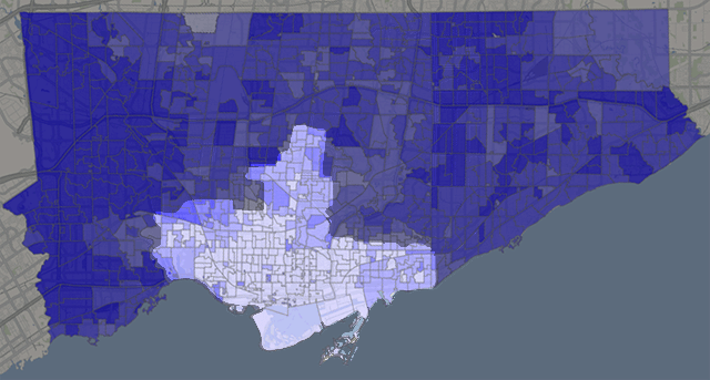
However, this last conclusion is again undermined by mapping the results from individual polling stations rather than wards (see below). Here again, despite a more “fuzzy-edged” picture than the simple view, we can clearly make out that there were hardly any polls returning more than 40% support for Rob Ford within the boundaries of the pre-amalgamation City of Toronto. If anything, the distinction has become even more accurate against the exact boundaries of the former City!

Percentage of mayoral votes cast for Rob Ford by poll (by Patrick Cain at patrickcain.ca), move over with mouse to superimpose Old City of Toronto boundaries

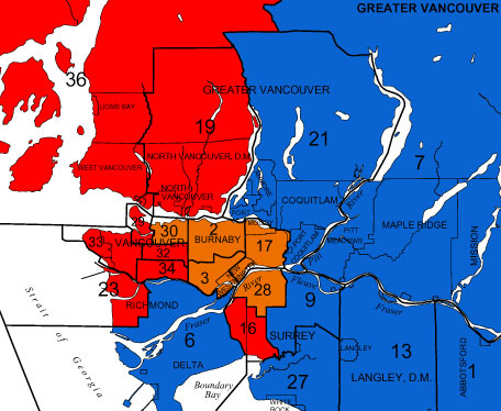
The unfortunate by-product of this strange correlation is a continued, and perhaps increasing animosity between the inner-city and the inner-suburbs. One is always blaming the other for forcing upon them the policies and direction representative of the politics of the “other”, pointing out how politically (and I think we can venture culturally, though not in the multicultural kind of sense) different and divided the two parts of the city really are. This fundamentally calls into question the wisdom (or perhaps, the true intent) of amalgamation. Given the choice, Toronto’s “inner-suburbs” would probably vote for Hazel McCallion if they only could, and perhaps the inner-suburbs should have been amalgamated with all the adjoining suburban areas that have a similar mindset, leaving the old City of Toronto alone at the centre, pursuing its bohemian, “crazy”, socialist, leftist (or simply centrist) path. After all, the City of Vancouver has hardly suffered by maintaining its old boundaries, and if anything has had a creeping, positive effect on the surrounding suburban municipalities, enncouraging them to progress on their own, little by little, at their own pace.

Image 01Image 01

Gardiner to Come Tumbling Down… kind of

Parliament St & Waterfront Blvd

In an announcement with significant ramifications for the waterfront, the much-maligned Gardiner Expressway is to come tumbling down…. at least part of it. Waterfront Toronto, the City and the provincial Ministry of Public Infrastructure Renewal together appear to have stumbled into a momentous decision with the removal of funding for the Front St Extension and the (resulting?) decision to demolish the portion of the Gardiner from east of Jarvis to the Don Valley Parkway.

Lower Jarvis St & Waterfront Blvd

In these images released today, Waterfront Toronto gives us an idea of what the demolition of the Gardiner may mean at street level. And frankly, if this is the way it’s handled, it looks fantastic – with the added benefit (not shown in the renderings) that the railway corridor is not as wide by the time it gets to Jarvis, meaning there could be a window of hope for a relatively pleasant passage down to the lake for the East Side, all of a sudden making Waterfront Toronto’s proposed developments at West Don Lands, East Bayfront and in the future at the portlands, seem far more connected and potentially vibrant. Could this be a great day in the history of Toronto’s waterfront?

Hold your horses there…. I’m not so sure. While clearly this is a decision many of us have been gagging for for years (nay, decades!), in typical Toronto fashion are we bollocking up one of the most important decisions in the city’s planning history? While the renderings show a relatively tamed boulevard at grade (along the lines of University Avenue perhaps), the plan almost seems a slap in the face to the functionality of the Don Valley Parkway and the Gardiner combined. Now in a way it’s great that expressway functionality is not determining the decision making here, but this decision has huge ramifications on two very important roads that currently connect and essentially function as one road. While many will say “who cares”, what exactly are the expected traffic volumes on this at-grade road and how tamed and crossable will this really make it? I mean if it’s essentially a Gardiner at grade with a pedestrian signal every 5 minutes, I’m not so sure this is a good thing.

But apart from that, the mind-boggling, ridiculous, tear-you-hair-out frustration of this scheme is that if you’re making such a mess of the Gardiner and its “flow”, doesn’t it just make sense to demolish the whole damn thing while you’re at it (at least make it part of the plan to do so!)? Why on earth should the Gardiner remain above grade as it crosses the foot of Yonge Street, the most important damn street in the City and the Province, and come down at Jarvis? If you’re screwing up the Gardiner anyway, and the projected volumes are nice enough to cross at grade, then bring the whole damn thing to grade out at Strachan and open up Fort York to the lake, give City Place a chance to be an actual place, and dish out the benefits to the whole central waterfront while you’re at it.

But no. Just like Toronto to do something like this half-assed and (surprise, surprise) solely for the benefit of Waterfront Toronto’s proposed developments alone. Message delivered: central waterfront, go f**k yourself!

Area to be demolished

GTA population grows by 9.2% since 2001

statcan_toronto_cma.jpg

Statistics Canada has started to release data from the 2006 census at the City level – including population figures for Toronto and the GTA (or at least the Toronto Census Metropolitan Area (CMA), mapped above). By this measure, the GTA has grown 9.2% since 2001, with a population of 5,113,149 – that’s an increase in population of 430,252 in five years. The City of Toronto itself accounted for only 21,787 of this increase (with a very modest growth rate of 0.9%, and despite what most of us would think of as a significant high-density condo boom) which gives you an idea of the massive pressure on land development at the edges of the city.

To put that in perspective, the increase is equivalent to adding the entire Kitchener CMA (which includes Kitchener-Waterloo and Cambridge)(451,235), or the entire London (ON) CMA (457,720) to the GTA in the last five years. That’s very nearly the entire population of Newfoundland and Labrador (505,469), and eerily near the population of the City (not CMA) of Vancouver (578,041).

This only emphasizes the critical importance of GTA-wide planning along the lines of the Places to Grow work being done by the Province, but also makes one wonder where this type of planning was 10 or 20 years ago when we really needed it. If this kind of growth keeps up, the Provincial target to have 40% of new residential units inside the current urban boundaries is going to be a real challenge.

Planning in Ontario – Part I: The OMB

With all the bad blood that the Queen West Triangle planning and OMB extravaganza has created in Toronto (see Active 18, spacingwire posts here, Reading Toronto here), it’s worth reflecting on the true nature of planning in Ontario.

Anyone familiar with the Ontario Municipal Board (OMB) process will know that the “Board” is in fact essentially a kind of court (dare we say kangaroo court?), where land use planning disputes are frequently heard when someone doesn’t like the decision made by the municipal planners or politicians. The process really boils down to lawyers arguing before a judge, using “experts” from the professions as both hired witnesses and fabricators of “evidence”. Anyone who thinks that that sounds a little strange must be new to the bizarre world of planning in Ontario.

In the spirit of openness that our planning system should be engendering, let’s get some help from Ambrose Bierce’s wonderful century-old Devil’s Dictionary for some enlightenment on the process (an online version of the dictionary is wideley available as copyright has expired, try here).

Bierce defined a lawyer as:

LAWYER, n. One skilled in circumvention of the law.

Who better to be in control of key planning decisions in Ontario?

But wait, there’s more!

The profession of planning in Ontario seems to be held in such poor esteem by the populace that despite widespread disgust with the OMB and its (perceived) pro-development decisions, there seems to be minimal support for planners having any more control over planning either! Who needs those silly professions after all?

Luckily, Bierce can help us out again to clarify what planners are trying to do in the first place.

Bierce defined to plan as:

PLAN, v.t. To bother about the best method of accomplishing an accidental result.

Sound familiar?

We might go so far as to say that such a definition of plan largely applies to public planning in this province. Private (consulting) planning might be better represented by an amalgam of the two thusly:

PLANNER (PRIVATE), n. One skilled in circumvention of the plan.

Enough said! Lesson 1 of a 106 part series, “Planning in Ontario”!

Gardiner’s No Innocent

south-parkdale-1950s.jpg

The demolition of South Parkdale circa 1956 to make way for the Gardiner Expressway, from Mike Filey’s “A Toronto Album 2: More Glimpses of the City That Was.” In Filey’s sanguine words:

“One minor problem associated with building the new highway was the need to demolish approximately 150 houses in the south Parkdale part of town – oh well.”

Oh well? For comparison, there are 262 homes currently on the Toronto Islands. The most striking thing you might notice about this stunning photograph is how the neighbourhood of south parkdale directly faced and related to the western waterfront across Lakeshore Boulevard – something almost unrecognizable along the western waterfront today since the area was excavated to build this section of the Gardiner. Note too the frequency and intimacy of the bridges crossing the railway corridor – a level of waterfront connectivity totally lost upon redevelopment and demolition (edit: a commenter pointed out that all 3 bridges in the photo still exist, it just seems like they knit the two sides together better because in the photo they do not end up at on ramps, highways and empty leftover green space as they do today).

Most interesting of all though, is how a whole neighbourhood like this can disappear without a trace. Were it not for Mr. Filey’s book, I would never have known, not being old enough to remember a different Toronto waterfront. In all the hubbub about the work of the TWRC and the revitalization of the Toronto waterfront, it’s worth remembering that we had a great waterfront once upon a time, and systematically, with cruel logic, we threw it all away. May we remember our lesson, and not let it happen again.

Cities & Politics – urban election results

OK – sorry this took a couple of days – here are the election riding results for urban areas to compare with the pre-election situation of the last post. “Ring Around the Liberals, A Pocket full of Layton. Tories! Tories! We all fall down!” I’ll leave the analysis to the wogs. Well done Vancouver for the largest concentration of NDP seats seen in some time (5 contiguous seats!), and shame on you Alberta – the only province (well – apart from PEI which only has 4 seats) to elect candidates from only one party (boring for the map, no doubt boring in reality) – even the Quebecois have never done that! Kudos to Olivia Chow, Layton and Peggy Nash for stopping Toronto from becoming a big red rash on the country.


Cities & Politics – an election eve treat

Canadian cities outside of Alberta have a little antipathy towards voting Conservative, though suburban areas get increasingly Conservative the further out you get. This all seems like common sense – but for your viewing pleasure (and oddly showing the hard time the NDP has had winning seats even in inner cities) here are maps of the major cities across the country showing the current seat distribution as we go into tomorrow’s election. I think you can figure the colour-coding out. Props to Elections Canada for the mapping.