urbanism – landscape – ideas – theory – whimsy

Before Bay St Divided Yorkville
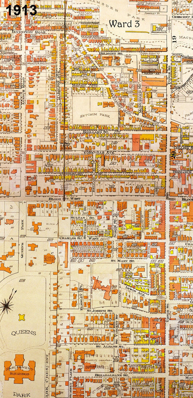
Goad Atlas fire insurance map showing the area between Yonge St and Queen's Park/Avenue Rd from near College St to Davenport Rd in 1913 - move over with mouse to see the same area in 1924 after Bay St was cut through

One of Toronto’s little historical secrets is the mystery of why Bay St does such a large jog at Queen St. History buffs may know the answer, but I only recently came upon it myself, and it answered many questions I’d long had about the strange disconnect in (of all places) Yorkville between Yonge St and the centre of what we now think of as Yorkville, the area west of Bay St.

The jog on Bay St creates one of Toronto’s most spectacular urban design moments, but it was far from deliberately planned that way – the placement of the tower of Old City Hall simply took advantage of a precondition in which Bay St ended at Queen St. What is today Bay St north of Queen St was originally a separate street running between Queen St and College St called Terauley St. Terauley St and the grid north of Queen St were originally laid out as part of a separate estate that did not line up with the grid south of Queen (even University Ave did not originally extend south of Queen St, whereas Yonge St was the exception as it was the original concession road).

North of College St there was a one block break, and then a series of streets with slightly different alignments (called St Vincent St, Chapel St and North St) continued the rough line of Terauley St north to Bloor St. North of Bloor St, no streets crossed through Yorkville along the Terauley St alignment. In the early 1920’s, the City decided to cut the Terauley alignment all the way through from Queen St to Davenport Rd and rename it as an extension of Bay St. The late date of Bay St’s creation north of Queen partly explains the lack of significant historical buildings along the street.

The effect in Yorkville has been more profound, as Bay St essentially split the old village in two. Originally, the centre of Yorkville was clearly along Yonge St (very few commercial buildings even existed at the time along Bloor St). Both the library and the fire hall were located close to Yonge St on Yorkville Ave. Since the 1920’s and the cutting through of Bay St, the fortunes of Yorkville west and east of Bay seem to have gone in different directions. While Yonge St has lost most of its connection to Yorkville and sense of it’s former individuality, Yorkville west of Bay was destined to become a centre for artists and alternative culture and finally a very unique boutique shopping district, maintaining a significant amount of its character and village feeling.
The Subway to Nowhere?

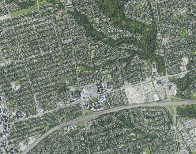
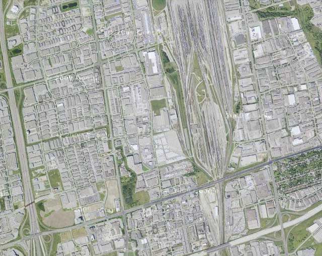
Vaughan north of highway 407 (source: google maps)

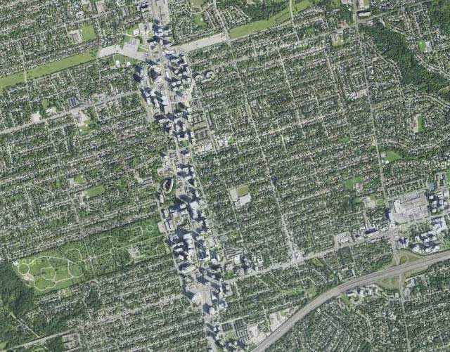
The Spadina subway extension to Vaughan is under construction and scheduled to be open for the end of 2015, but where exactly is this thing going? Sure it goes to York University (which I think most people would accept is a good idea), but there will be a full 2 more stations north of Steeles Ave into Vaughan, so what exactly is up there? See above… Oh dear… It looks like we’re extending a subway line that originally kind of went to nowhere, to another even more extreme nowhere, a vast sea of single-storey warehousing, manufacturing, big box stores and railway lands. But wait! Building a subway will result in massive development right? So this area is ripe for a total makeover, right? Oh wait a minute… here’s the famed subway-driven development along the Yonge St corridor north of highway 401 from Sheppard Ave to north of Finch at the same scale, the result of almost 40 years of development (see below).

Yonge St development corridor north of highway 401 at the same scale (source: google maps)

I guess the even more modest kind of development around the Sheppard Line wouldn’t have much of an effect either (see below).

Sheppard Ave development corridor north of highway 401 at the same scale (source: google maps)

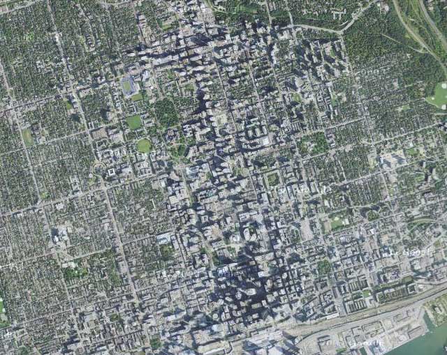
So just how large is this sea of nothingness that we’ve sent a subway line to? Oh, that’s right, as large as the entire downtown core of Toronto (see below). Damn.

Downtown Toronto from the Union Station to Bloor at the same scale (source: google maps)

Toronto’s inner-city/inner-suburb political divide continues

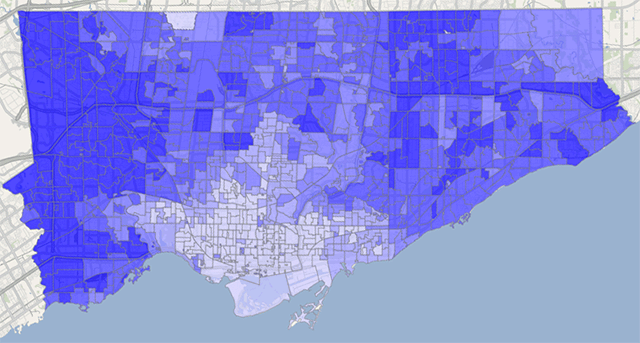
2010 Toronto Mayoral Election results by ward (by Marc Lostracco/Torontoist.com), move over with mouse to superimpose Old City of Toronto boundaries

In what one commenter called Mike Harris’ gift that keeps on giving (or rather, the pain that keeps on hurting), Toronto’s 12 year-old forced amalgamation continues to have significant and divisive ramifications on the City’s choice of mayor. The post-amalgamation political divide is frequently characterized as an urban/suburban divide, which in some ways it is, although in reality it simply follows the boundaries of the old pre-amalgamation City of Toronto, while the so-called “suburbs” are today so far from the edges of the metropolitan area that the name is slightly misleading (especially as in Toronto proper the suburbs tend to be poorer and very culturally diverse), and so I’ve called it the inner city/inner suburb divide instead. What the divide has meant is that it is easily possible for the Mayoral choice of the outer city to dictate the electoral result regardless of how the inner city votes, but in general not the reverse. In last week’s election, this was again the case, perhaps more clearly proved by the data than in any previous election (yes, even more so than the Mel Lastman years!), with outer Toronto clearly preferring Rob Ford, and the inner-city pre-amalgamation City of Toronto preferring George Smitherman.

While some may feel that a more “nuanced” view can be gained by mapping the amount of support the leading candidate in each ward received, this does not really change the simplified overall trend, but does suggest that “downtown” culture seems to play a big role in this political divide (see below).

Election 2010 results weighted (Map by Marc Lostracco/Torontoist.com)

However, this last conclusion is again undermined by mapping the results from individual polling stations rather than wards (see below). Here again, despite a more “fuzzy-edged” picture than the simple view, we can clearly make out that there were hardly any polls returning more than 40% support for Rob Ford within the boundaries of the pre-amalgamation City of Toronto. If anything, the distinction has become even more accurate against the exact boundaries of the former City!

Percentage of mayoral votes cast for Rob Ford by poll (by Patrick Cain at patrickcain.ca), move over with mouse to superimpose Old City of Toronto boundaries

The unfortunate by-product of this strange correlation is a continued, and perhaps increasing animosity between the inner-city and the inner-suburbs. One is always blaming the other for forcing upon them the policies and direction representative of the politics of the “other”, pointing out how politically (and I think we can venture culturally, though not in the multicultural kind of sense) different and divided the two parts of the city really are. This fundamentally calls into question the wisdom (or perhaps, the true intent) of amalgamation. Given the choice, Toronto’s “inner-suburbs” would probably vote for Hazel McCallion if they only could, and perhaps the inner-suburbs should have been amalgamated with all the adjoining suburban areas that have a similar mindset, leaving the old City of Toronto alone at the centre, pursuing its bohemian, “crazy”, socialist, leftist (or simply centrist) path. After all, the City of Vancouver has hardly suffered by maintaining its old boundaries, and if anything has had a creeping, positive effect on the surrounding suburban municipalities, enncouraging them to progress on their own, little by little, at their own pace.

Image 01Image 01

History in the Junction: Part I

290_9005

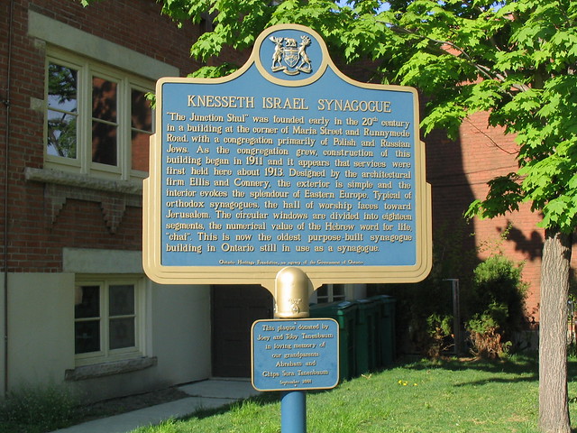
Knesseth Israel Synagogue (also called “The Junction Shul”) at 56 Maria St in the Junction in Toronto just off Dundas St W. The building was built starting in 1911 and  is a designated heritage building and also has an Ontario Heritage Foundation plaque.

The building dates from a time when the Junction was a key centre of industry for Toronto, drawing many working class immigrants to the plentiful jobs.

The historical plaque reads:

“The Junction Shul” was founded early in the 20th century in a building at the corner of Maria St and Runnymede Rd, with a congregation primarily of Polish and Russian Jews. As the congregation grew, construction of this building began in 1911 and it appears that services were first held here about 1913. Designed by the architectural firm Ellis and Connery, the exterior is simple and the interior evokes the splendour of Eastern Europe. Typical of orthodox synagogues, the hall of worship faces toward Jerusalem. The circular windows are divided into eighteen segments, the numerical value of the Hebrew word for life, “chai”. This is now the oldest purpose-built synagogue building in Ontario still in use as a synagogue.

The dedication reads:

“This plaque donated by Joey and Toby Tanenbaum in loving memory of our grandparents Abraham and Chipa Sura Tanenbaum, September 2001”

290_9006