
A plea for more seating

With summer fast approaching, we’ll be seeing more and more people out on the streets, hanging out, talking, eating their lunches and generally enjoying being outside – as Canadians tend to do when fine weather brings us out of winter’s clutches. But where are they doing all these things? Surely we’re not all standing around on street corners, loitering in front of doorways or squatted on the pavement?
No, it’s this time of year when finding a plum bench or seat in a nice location at lunch time is something like trolling the streets looking for a parking space. But is the culprit just too many people in a concentrated area all out at the same time, or is it really that we have a sadly deficient amount of seating in public areas in Toronto? And I don’t just mean benches – seating walls, stairs, ledges, chairs, window wells – people will sit on almost any horizontal surface within reach (as the couple in the photo above show in such intimate fashion).
It certainly seems as though in many of the most bustling parts of the city there are hardly any places to sit along streets or at intersections where all the action is happening. I hope that we can improve on the current situation in future, and sincerely hope that the current transformation of Toronto’s waterfront will provide ample (nay, over-ample!) seating of every kind and for every occasion.
Photo: Couple seated in a wall along Balmuto Ave opposite the Manulife Centre
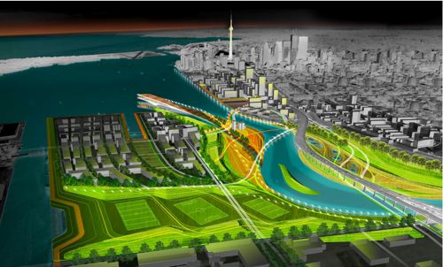
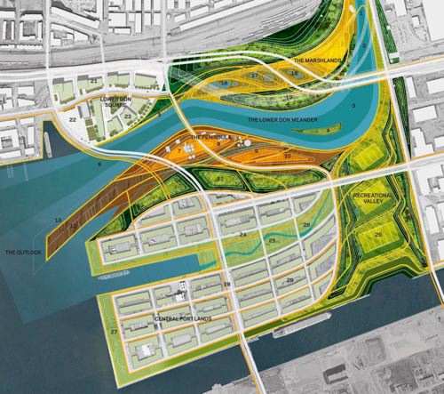
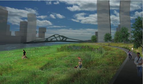
MVVA wins Lower Don Lands competition
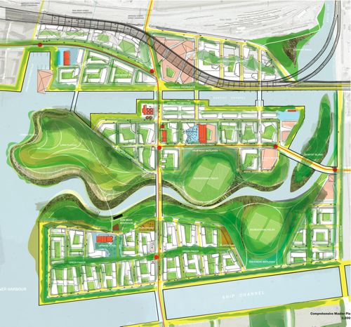
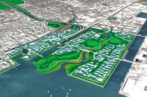
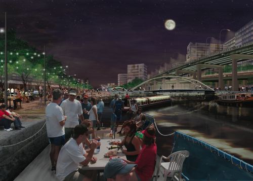
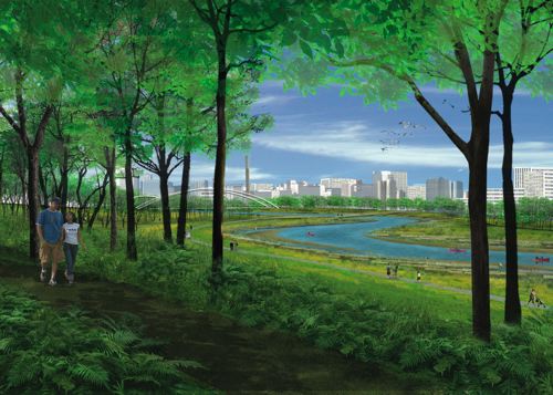
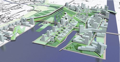
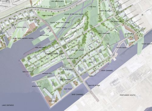
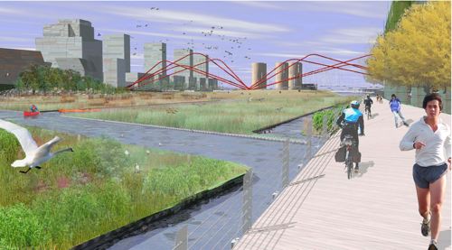
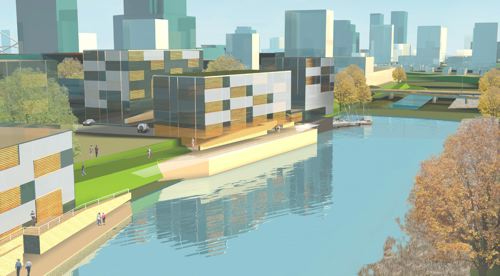
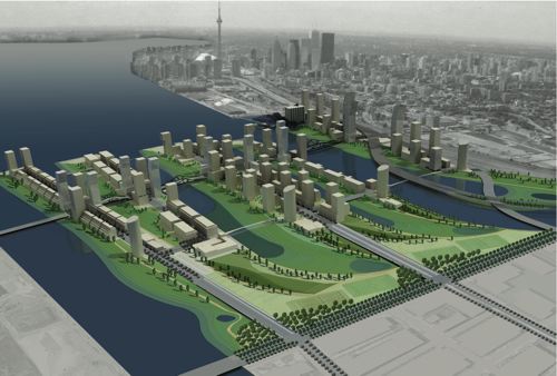
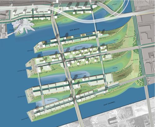
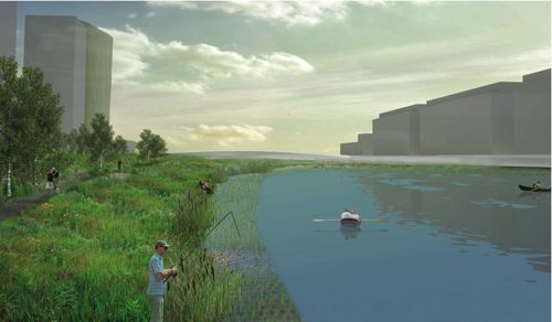
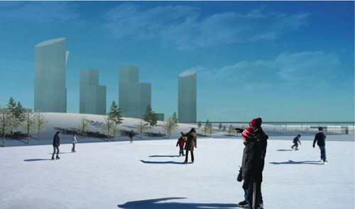
The TWRC announced yesterday that the Michael Van Valkenburgh Associates, Inc. (MVVA)/Behnisch Architects/Greenberg Consultants/Great Eastern Ecology team won the Lower Donlands Design Competition. More information on the team’s entry can be found at the TWRC site.
The full team included:
Michael Van Valkenburgh Associates, Inc. (MVVA), New York & Massachusetts, USA
Limno Tech Inc., Michigan, USA
Applied Ecological Services Inc., Wisconsin, USA
Great Eastern Ecology, New York, USA
Greenberg Consultants Inc., Ontario, CANADA
Behnisch Architects, Los Angeles, CA, USA & Stuttgart, DEU
Transsolar Energietechnik, New York, USA & Stuttgart, DEU
RFR Engineering, Paris, FR
Totten Sims Hubicki and Associates (TSH), Ontario, CANADA
ARUP, Ontario, CANADA
Congratulations (and commiserations) should also go to the other teams for very fine submissions, particularly the Weiss/Manfredi DTAH scheme which I’m sure was a very close second.
Designs released for Lower Don Lands
The designs for the Lower Don Lands from the 4 shortlisted teams in the “Innovative Design Competition for the Lower Don Lands” being run by the TWRC were released today in conjunction with an exhibition (including lovely models) at BCE Place. The Exhibition Launch and Public Forum is on Monday April 16 from 6-9 pm at the Allan Lambert Galleria in BCE Place (181 Bay Street). PDF’s of the full display panels are available from the TWRC website.
———————————————————-
STOSS INC./Brown + Storey Architects/ZAS Architects
STOSS INC., Boston, MA
BROWN + STOREY ARCHITECTS, Toronto, ON
ZAS ARCHITECTS Inc., Toronto, ON
Brookner Studio
Nina-Marie Lister
Applied Ecological Systems
Pine + Swallow Associates
Nitsch Engineering, Inc.
Moffatt + Nichol
ARUP
Kidd Consulting
Consult Econ, Inc.
The Map Office
———————————————————-
MVVA/Behnisch Architects/Greenberg Cnsltnts/Great Eastern Ecology
Michael Van Valkenburgh Associates, Inc. (MVVA), New York & Massachusetts, USA
Limno Tech Inc., Michigan, USA
Applied Ecological Services Inc., Wisconsin, USA
Great Eastern Ecology, New York, USA
Greenberg Consultants Inc., Ontario, CANADA
Behnisch Architects, Los Angeles, CA, USA & Stuttgart, DEU
Transsolar Energietechnik, New York, USA & Stuttgart, DEU
RFR Engineering, Paris, FR
Totten Sims Hubicki and Associates (TSH), Ontario, CANADA
ARUP, Ontario, CANADA
———————————————————-
Weiss/Manfredi & du Toit Allsopp Hillier
Weiss/Manfredi, New York, NY
du Toit Allsopp Hillier (DTAH), Toronto, CANADA
McCormick Rankin Corporation
Golder Associates Ltd.
Biohabitats, Inc.
———————————————————-
Atelier GIROT/Office of Landscape Morphology/ReK Productions
Atelier GIROT, Zurich, Switzerland
Office of Landscape Morphology, Paris, FRANCE
Jürgen Mayer H., Berlin, GERMANY
ReK productions
Arup, California, USA
Philip Ursprung
Applied Ecological Services
PLANT wins Nathan Phillips Square competition
Plant Architect & Shore Tilbe Irwin were announced the winner of the Nathan Phillips Square competition. For more information on the competing schemes see the Spacing Wire post or the City of Toronto’s website.
The rest of the team members were:
- Peter Lindsay Schaudt Landscape Architecture, Inc. (landscape design collaborator, Chicago)
- Adrian Blackwell (urban design collaborator and art consultant, Toronto)
- Blackwell Bowick Partnership Limited (structural engineering, Toronto)
- Blanche Lemko van Ginkel (historical guidance, Toronto)
- Crossey Engineering Ltd. (integrated mechanical and lighting systems design, Toronto)
- Enermodal Engineering Limited (environmental and sustainability design and integration, Kitchener, Ontario)
- Theatre Projects Consultants (theatre consultant, S. Norwalk, Connecticut)
- Vermeulens Inc. (quantity surveying, Richmond Hill, Ontario)
Lower Don Vision – bricoleurbanism style
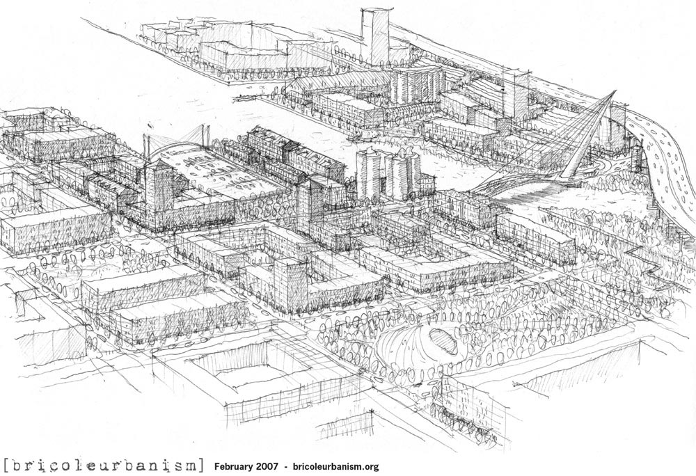
The TWRC recently put out a call to Torontonians for visions for the Lower Don Lands and the mouth of the Don River (see here), perhaps as a consolation for the closed, restrictive process they seem intent on following for their “Innovative Design Competition for Toronto’s Lower Don Lands” for which they released a shortlist on 2 February (see here).
Maybe they thought that the Innovative Design Competition for the Central Waterfront (see here) was so successful, they figured they’d just do the same thing over again. At least it’s clear that they’re intent on moving forward with winning schemes into implementation, which is not always the case.
But starting off with an RFP process is hardly a way to get the maximum number of people involved. While they say that they’re “seeking input from the world’s most talented and creative design and engineering professionals in developing bold new concepts for the Lower Don Lands area”, it hardly seems likely that the world’s most talented and creative people have been boiled down to the 5 shortlisted teams. The proposals themselves are never released publicly, only the finalists’ entries are, so at best we get 5 concepts to publicly review and have to rely on the wisdom of the shortlisting process to have chosen teams that might produce the most innovative design responses.
While the process obviously can work (quite a bit of attention was generated with the Central Waterfront competition), it does have drawbacks – the winning team for the Central Waterfront (West8/DTAH) was a clear winner since most people were less than impressed by the other teams’ submissions. The fact that the Nathan Phillips Square competition (see here) is being run in the same way, makes it clear that a wide spectrum of ideas is not what public agencies in Toronto are really after.
Which leaves some designers and Torontonians (either those not shortlisted, or ineligible to compete by virtue of not being on a team with all the requirements demanded by the RFP) shit out of luck. Cue the “Submit Your Vision for Toronto’s Lower Don Lands”. However, being limited to a single double-sided letter sized page is certainly unusual for most designers, so it’s obvious that they really are looking for the ideas of the average Torontonian.
And as for design students, who traditionally are keen submitters to competitions (if only because their studios are often based on a current competition), whatever ideas they may have come up with, they’d better fit on that double-sided page too.
So, even if only to get the ball rolling and get some ideas out in public (where’s the TWRC going to hide all the visions submitted by Joe Public?), bricoleurbanism.org is proud to here present our vision for the Lower Don Lands. Click on the images to view the full drawings.

Gardiner’s No Innocent
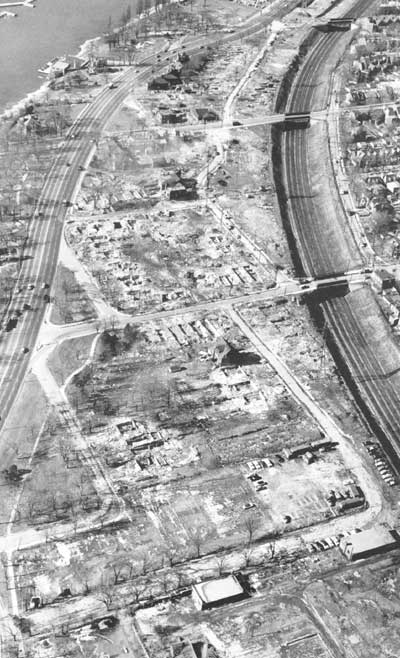
The demolition of South Parkdale circa 1956 to make way for the Gardiner Expressway, from Mike Filey’s “A Toronto Album 2: More Glimpses of the City That Was.” In Filey’s sanguine words:
“One minor problem associated with building the new highway was the need to demolish approximately 150 houses in the south Parkdale part of town – oh well.”
Oh well? For comparison, there are 262 homes currently on the Toronto Islands. The most striking thing you might notice about this stunning photograph is how the neighbourhood of south parkdale directly faced and related to the western waterfront across Lakeshore Boulevard – something almost unrecognizable along the western waterfront today since the area was excavated to build this section of the Gardiner. Note too the frequency and intimacy of the bridges crossing the railway corridor – a level of waterfront connectivity totally lost upon redevelopment and demolition (edit: a commenter pointed out that all 3 bridges in the photo still exist, it just seems like they knit the two sides together better because in the photo they do not end up at on ramps, highways and empty leftover green space as they do today).
Most interesting of all though, is how a whole neighbourhood like this can disappear without a trace. Were it not for Mr. Filey’s book, I would never have known, not being old enough to remember a different Toronto waterfront. In all the hubbub about the work of the TWRC and the revitalization of the Toronto waterfront, it’s worth remembering that we had a great waterfront once upon a time, and systematically, with cruel logic, we threw it all away. May we remember our lesson, and not let it happen again.
Windows Live Local Preview ups the ante on VirtualCity
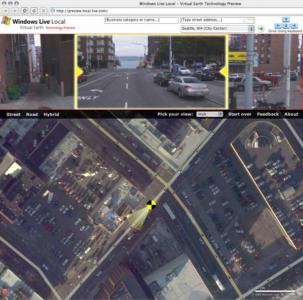
The Windows Live Local Preview ups the ante on the previously reported VirtualCity.ca (see post on Virtual City here). The Live Local Preview is only available for Seattle and San Francisco thus far, but the service (perhaps less practical than VirtualCity’s) has distinct experiential advantages. Instead of the side-on streetscape views focussed on the built form and shops, the Live Local Preview gives an experiential view down the street, with smaller views to left and right – and you can also essentially walk your way around with the detailed airphoto serving as a map. As you move location, the view changes relatively smoothly, essentially resembling video footage or a photo sequence of your walk. If you don’t choose “Walk” from the drop down window, you end up confined behind a car’s steering wheel looking through the windshield (boring!). Switch to “Street” view on the airphoto and you’re given the streetscape on either side as a continuous photomontage (if you’re zoomed in close enough), but it’s a bit small and couldn’t get it zoomed in any further. Using the mouse wheel lets you zoom in and out. On my Mac the interface was still a little clunky and unresponsive, but being a Windows release no doubt it’s optimized for Internet Explorer.
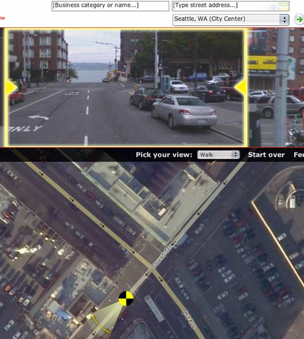
This is yet another step towards the seamless exploration of a city from a computer. Combine features of VirtualCity.ca and the Live Local Preview and you’re really getting somewhere. Some might tend to think that this suggests that at some point in the future no one will bother to explore their own city, and that all of the secret hidden locales of a city will be bared and exposed to the world, and that perhaps this will somehow ruin them. There’s an argument for saying that, but I’m not buying it. The amazing record that these sites are creating of certain cities at certain times is nothing short of amazing. The spatial and social experience of the city will always endure over virtual copies, especially so since the virtual copies are not even meant to replace the physical in the first place, they are tools enabling understanding, comprehension and evaluation of the city, while at the same time being a documentation of the unique physical reality of each city (at the human level) of extreme value.
Props to Tone for the heads up!
VirtualCity.ca delivers the real thing
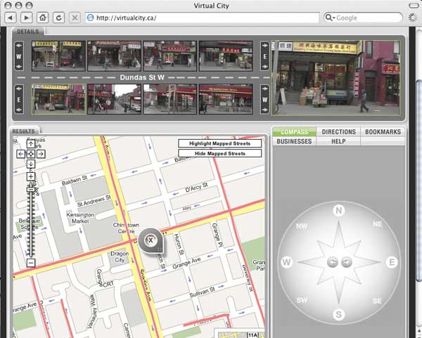
Readers of the Globe & Mail might have come across a reference to this amazing new site in last Friday’s Globe Review supplement – in case you missed it, I’m pleased to clue you in to something that will soon become indispensible and boundlessly useful for any city. The article by Ivor Tossell called “VirtualCity delivers the real thing” can be accessed (for now) here.
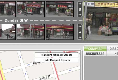
In short, virtualcity.ca has matched continuous photography of the entire streetscapes (primarily storefronts) of most of Toronto’s main streets to a google maps mapping system. All of a sudden, instead of the anonymous satellite photography of google maps, you can find exact views of the street corner you want to meet someone on, the restaurant you want to dine at, the apartment you’re on your way to see, etc. It’s amazing and near unbelievable. In fact, you can type in an address and find streetscape photography of it immediately. The site creators are working on adding residential streets to the system as well and a site for Montreal is in the works! Thank God for the internet! In Mr. Tossell’s nice words:
VirtualCity’s photos are more like day-in-the-life snapshots. Pedestrians walk the sidewalks. Streetcars and fire trucks obscure edges of the frame. You can see the detritus on front porches, recycling in the alleys, cars parked on the margins and the tail ends of streetcars retreating out of view. It’s a celebration of the urban mundane…
In trying to render a business service, VirtualCity has made a documentary of our streets that’s dispassionate, yet totally intimate. Indeed, the site is misnamed: It promises a virtual city, yet delivers the real thing, unadorned, grimy, on a lousy day, with fire trucks getting in the way of the camera.
And best of all by clicking on the top-right larger version of the active image you can view or download very high resolution images so that you can read store signage, check out street numbers or any number of things. I’m sold.
Kazakhstan Field Patterns

Collective Farms, Komsomolets, N. Kazakstan, April,2002
Geometrical field patterns in Kazakhstan created by dense plantings of tree rows as windbreaks. In the wake of the Borat controversy, it’s nice to step back a bit and discover something truly amazing and beautiful about the little-known country. The 3-dimensionality is eerie…
“This early spring view shows a rectangular maze of collective farms near the city of Komsomolets in northern Kazakstan. The “walls” surrounding the farms are actually dense rows of trees that serve as windbreaks. Snow has piled against the trees, which along with the accompanying shadows gives the scene a 3-dimensional appearance. The windbreaks were planted shortly after collective farming began in northern Kazakstan in the 1950’s, when it became evident that wind erosion of the soil was a problem. Also shown is a major roadway extending from lower right to upper left, crossing the Tobel river near Komsomolets, which appears as a dark circular patch mid-way up the left border of the scene.”
From the Landsat satellite gallery at the USGS

An ongoing series of reflections on the city, the landscape and the fields that manipulate them from the perspective of urban design, landscape architecture, Toronto and Canada.
Search
Site Feeds
Posts RSS
PaD Shanghai Photos RSS
From the Vault Photos RSS
Pages
Categories
- Beautiful Urban Moments (35)
- Buildings (1)
- China (17)
- Cities (12)
- Cities & Politics (8)
- Cyclism (11)
- Development (8)
- Development in Toronto (28)
- From the Vault (41)
- History (7)
- Ideas (30)
- Landscapism (31)
- PaD Shanghai (153)
- Shanghai (13)
- Theory (12)
- Toronto (4)
- Transit (12)
- Urban Design (50)
- Urbanism (15)
- Whimsicality (132)
Archives
Related & Interesting
Documentation
Plugins
Suggest Ideas
Support Forum
Themes
WordPress Blog
WordPress Planet