urbanism – landscape – ideas – theory – whimsy

Requiem for Wujiang Lu food street

Wujiang Rd Demolition

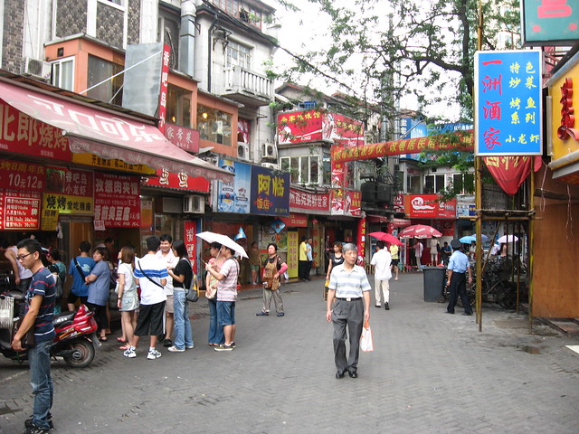
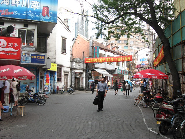
Wujiang Rd Demolition Before-After 1 (move over photo with your mouse to reveal After photo)

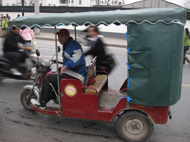
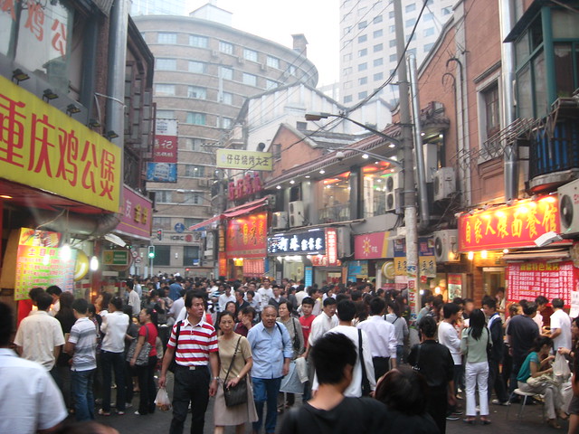
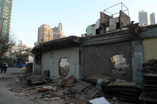
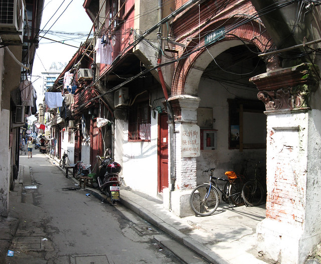
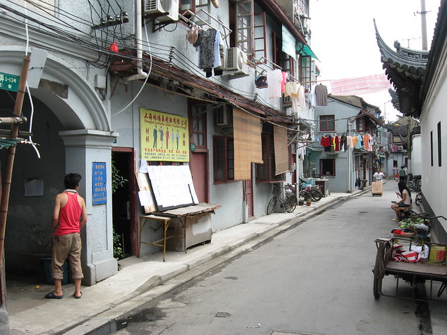
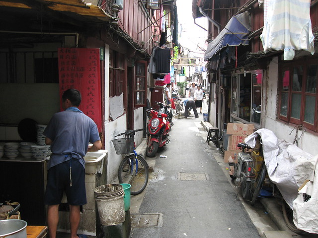
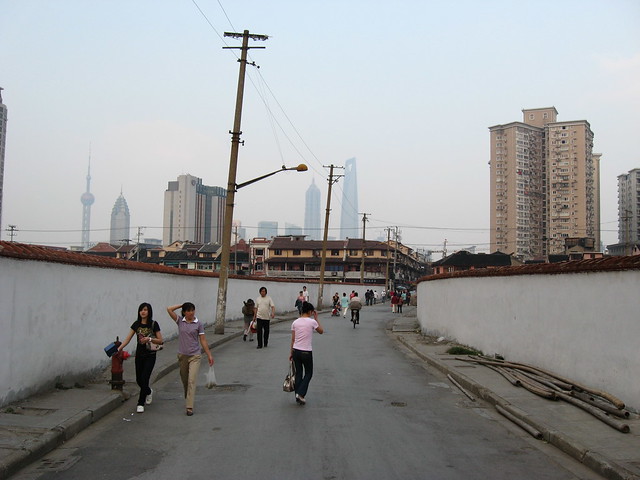
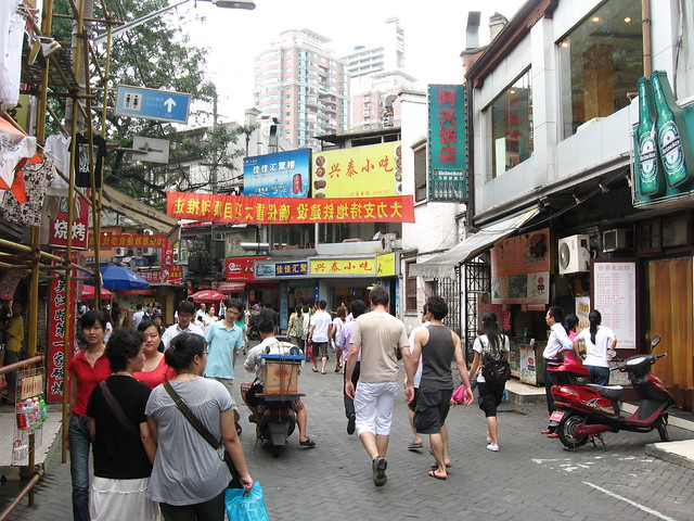
The remaining original portion of Wujiang Lu (吴江路) food street (east of Shimen Yi Lu 石门一路) is being demolished. The pedestrian food street has (or soon to be had) a very distinctive (dare I say delicious) curve to it which may be disappearing forever once demolition is completed. I previously reported on the contrast between the character of the food street and the earlier redevelopment of the portion west of Shimen Yi Lu and gave some history of the street itself. This post however is more about reflecting on yet another loss for Shanghai’s streetlife, so here are some before/after photo rollovers I’ve prepared (so we can kick it like it’s 1996) – first photos were taken around dinner time in October 2008 when it was absolutely crowded, rollover photos are from February 2010 in the midst of demolition.

Wujiang Rd Demolition

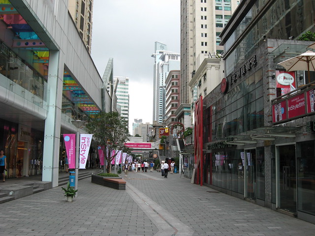
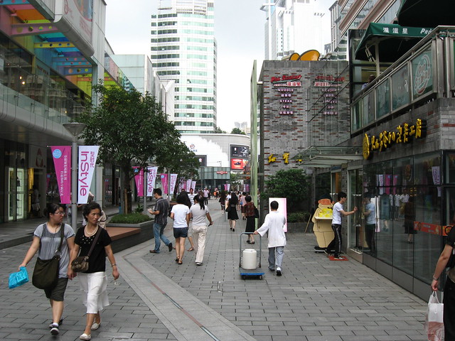
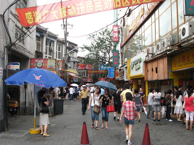
Wujiang Rd Demolition Before-After 2 (move over photo with your mouse to reveal After photo)

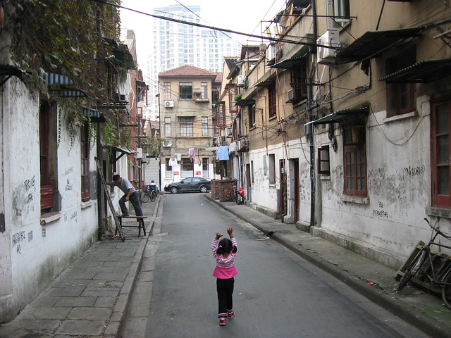
And another from further east:

Wujiang Rd Demolition

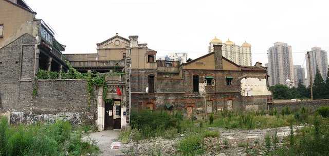
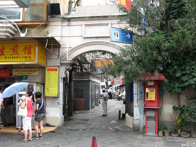
Wujiang Rd Demolition Before-After 3 (move over photo with your mouse to reveal After photo)

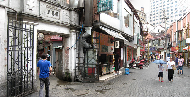
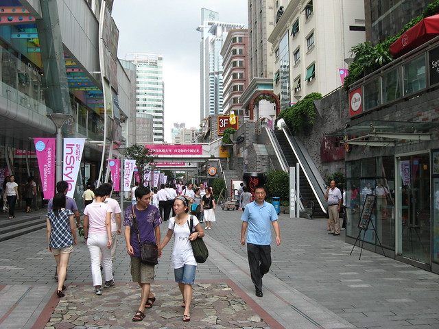
And another from nearer Shimen Yi Lu:

Wujiang Rd Demolition

Wujiang Rd Demolition Before-After 4 (move over photo with your mouse to reveal After photo)

Below you can access my Flickr set slideshow “Requiem for Wujiang Rd” that I made as an act of remembrance – you can see full size versions of these before-afters as well as other photos of Wujiang Lu before demolition began, and some video compilations at end.

Wujiang Lu (吴江路) Requiem

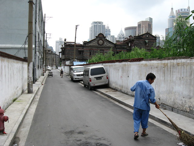
Below you can access my Flickr set slideshow of photos during demolition of Wujiang Rd and the small lane neighbourhoods to its north and south (the two videos below also appear at the end).

Wujiang Lu (吴江路) Demolition

I made a couple of videos walking through Wujiang Lu and the small lane district on its south side on February 24th 2010, (Flickr only allows 90 second videos so it’s split it into two parts). See below (note, videos have music).

In google earth you can see what will become of Wujiang Lu by comparing the fate of the lane neighbourhood to the south that was demolished sometime after November 2006 – see before/after mapping below (Wujiang Rd is the curving lane through the top part of the neighbourhood):

Google Earth Imagery of Wujiang Lu area in 2006 and 2009

Google Earth Imagery of Wujiang Lu area in 2006 and 2009 (move over image with your mouse to reveal After image)

I won’t comment too much about this because it makes me too angry and sad to see something that was so popular and fascinating wiped away for more bland corporate anywhere urbanism.

Image 01Image 02
Image 03Image 04Image 05

Shanghai’s metro during rush hour

Three videos to show the kind of crowd volumes that Shanghai’s People’s Square metro station (interchange for lines 1, 2 and 8 ) experiences during a typical rush hour – the unending sea of people is slightly mind-boggling, but by keeping with the flow an enormous number of people can peacefully get from A to B (the story on the platforms when the train doors open is a lot less peaceful). Click on the HD button to get higher quality video when viewing fullscreen.

Old Town Shanghai

401_2166-pan

Danfeng Lu between Wutong Lu 梧桐路 and Fangbang Zhong Lu, Nan Shi 南市 (Southern City, Chinese Old Town)

A misunderstood and underestimated side of Shanghai, the “Chinese Old Town” (called Nan Shi 南市 or Southern City by locals) is the truly historic district of this complex and cosmopolitan city, with the street fabric and many buildings far predating any of the development of the Concessions while controlled by the foreign powers.

401_2076

Anren Lu behind the east wall of Yuyuan Garden

Frequently (and erroneously) dismissed as simply an insignificant “fishing village” before the area was opened to foreign trade by the Nanjing Treaty of 1842, Shanghai was in fact already a significant Chinese port and trading city with as large (or greater) a volume of shipping as contemporary London (at least according to Lynn Pan in “Shanghai Style: Art and Design Between the Wars“). The core of the city was surrounded by a 5km circle of walls built in 1553 to protect against Japanese pirates, the line of these walls is preserved today by a circle of streets built after their demolition (Renmin Lu and Zhonghua Lu). Outside the walls running down to the Huangpu River was a large commercial, warehouse and port district, with a “forest of innumerable masts” at its wharves.

400_3437-pan

A remnant building that's survived demolition in a large cleared district of demolished buildings off Qinglian Jie and Wanzhu Jie

401_2205

Same building 8 months later with empty site now a forest of weeds

Sadly, today large areas of the Old Town have been demolished and the former walled city is divided into 4 parts by two large traffic arteries cut through its fabric (Henan Nan Lu and Fuxing Dong Lu). Worse still, its position as the historic origin of a great trading city is largely forgotten or ignored: many tourists simply visit the heavily restored and questionably antique Old Street (Fangbang Zhong Lu east of Henan Nan Lu), Yuyuan garden and pastiche tourist-trap Yuyuan Bazaar and feel they’ve “hit” the Old Town; expats are generally too enamoured with the faded glories of the French Concession to bother with it; and most locals seem more embarrassed by the Old Town than anything else, barely admitting to its existence, as though it doesn’t live up to the hype that is Shanghai, either its past glories or its future potential.

401_2133

Wutong Lu 梧桐路 between Danfeng Lu and Baodai Nong

But they don’t know what they’re missing, because the Chinese Old Town (as one would expect) is one of the few places in Shanghai where you can experience a truly Chinese urbanism and a genuine taste of what the city was like before the foreign devils forced their way in. Significant areas still survive filled with lively streetlife, small twisting lanes, and endlessly fascinating visual stimulation of a thoroughly different kind than in the historic lilongs of the French Concession. How much longer this old fabric will survive is anyone’s guess since most of the architecture is undervalued by locals in comparison to buildings such as Shikumen housing in the foreign concessions, and the fine street network is particularly unsuitable to high density redevelopment resulting in whole districts being levelled to create large parcels, with no trace of the hundreds of years old fabric beneath. Only time will tell how much of what remains will survive and in what form, but so far there seems to be relative restraint from officials compared to other districts of the city with regard to the upcoming 2010 Expo. I remain hopeful they will pursue a renovation/revitalization approach addressing living standards and servicing rather than the wholesale demolition that has been all too common in Shanghai.

Browse more photos Old Town Shanghai here at bricoleurbanism.org

…or here on my Old Town Shanghai Flickr Set

400_3431

Dajing Lu west of Luxiangyuan Lu with cleared sites of demolished buildings for development behind the walls

400_3461

A lane north off Fuchan Nong

Wujiang Lu: Past, Present & Future

401_1964-pan

Wujiang Lu food street, near Nanjing Xi Lu station

Wujiang Rd (吴江路) is a small street in Shanghai that has gone through several transformations in its history, from a den of vice, to a popular food street, to a high-end pedestrian “leisure” street. Situated in Jing’an district just off Nanjing Xi Lu near the subway station on Line 2, the street’s origins lie sometime before the 1860’s when its winding path following a creek made such a convenient shortcut that it became Shanghai’s first toll road and was known in chinese as Diamond Bridge Rd.

401_1958

Wujiang Lu was (rather ironically) called Love Lane when it was part of the International Settlement and was notorious from the 1920’s as a den of brothels and vice unparalleled even in the Shanghai of the time. “Despite its romantic name, everything was for sale on Love Lane.”

401_1972

At some point in later decades Wujiang Lu became a very popular food street with crowds of locals jostling for cheap treats from all over China. Unlicensed stalls lined the pedestrianized street competing with the small restaurants, some of them quite famous.

401_1954

"Wujiang Road Leisure Street" west of Shimen 1st Rd

Then along came the spectre of Expo 2010 and a very strong government desire to “clean up” places like Wujiang Lu. The section of the street west of Shimen 1st Rd was entirely demolished and replaced with “Wujiang Road Leisure Street”, a new pedestrian street of fashion boutiques and chain restaurants, a dull corporatized pedestrian mall. In events very typical of current chinese redevelopment, a place abounding in street life and food and shops affordable for most chinese locals has been replaced with expensive shops and restaurants targeted at the nouveau riche.

401_1949

401_1953

The section of Wujiang Lu east of Shimen 1st Rd has survived so far, but it seems has been cleaned up a lot and the unlicensed vendors removed. It’s unclear whether or not the short remaining block still has demolition looming over its head.

401_1971

401_1975

401_1976

Goods by Bicycle in China

goods-by-bicycle-grid_rev-web

Despite dramatic decreases in the number of cyclists in Chinese cities over the past 15 to 20 years, transport of goods and products, informal collection of recycling, deliveries and use of bicycles for retail and selling is still very common.

I’ve uploaded a photo gallery (Flickr set) of some of this activity easily seen in Shanghai. While Shanghai is in many other ways a very modern and advanced city, the continuing use of bicycles for so many purposes seems directly related to the presence of so many people willing (or forced) to work for extremely low fees, for which the bicycle remains by far the cheapest and indeed the only affordable means of transportation. Especially over short delivery distances, it would seem to many Chinese almost wasteful to use a truck.

400_9312

One of the few official agencies still using bicycles is China Post, whose beautiful green delivery bicycles (complete with panniers) can frequently be seen parked in front of buildings.

400_8125

Past and Future on Shanghai’s Famous Bund

2154216483_bbc615a6ef_b-crop2-sm Source

The Bund in the 1930's

Shanghai’s waterfront is synonymous with its history. The archetypal image of Old Shanghai is a view of the city’s former front door, the storied Bund along the Huangpu River, lined with ostentatious colonial banking and commercial buildings, symbols of Shanghai’s bizarre history of foreign control and profiteering. For New Shanghai, you simply have to turn your view across the River to Pudong, where a profusion of skyscrapers have sprouted on what was docks, warehouses and fields only 15 years ago, giving Shanghai as modern a skyline as anywhere.

400_9211

Pudong Skyline from the Bund

bund-1930s-crop Source

The Bund in the 1930's

Historically, the Bund was characterized by having an old port’s chaos of ships, wharfs, docks and cargo on the water side, and the dignified solidity of the city’s prime address on the other. In the past, this waterfront vibrancy tended to be the rule rather than the exception, but Shanghai took the activity to a delightful extreme with streetcar routes and plenty of promenaders on both sides of the street. Even so, you can clearly see parallels with historic views along the Old Port in Montreal, and doubtless many other cities.

bund-from-overpass-merge-crop-eSources 1and 2

View of the Bund in 2008 showing highway off-ramp (now demolished)

380494440_44f7029803-e Source

The Bund in 2006: 10 or 11 lanes of uncrossableness, including a raised median to stop anyone crazy enough to try jaywalking - I'm not sure if the trees will be saved

Unfortunately, Shanghai’s waterfront Bund is today a pale shadow of its former self. As in so many other cities, the waterfront was eventually seen as the easiest place to put a major cross-town traffic artery – in this case, at grade, though with a large flyover (now demolished) connecting to an elevated expressway. Ten or eleven lanes of through traffic later, the waterfront promenade that is such a major tourist attraction is as separated from the famous buildings that line the Bund (and the narrow sidewalk in front of them) as possible. At-grade pedestrian crossings are essentially outlawed for the entire length of the historic area, with pedestrians forced into underground tunnels to cross to the waterfront (a temporary pedestrian overpass during construction shows how wonderful it is to see what you’re crossing). Exasperating the strange and tenuous connection between the two sides is the elevation of the waterfront promenade a few metres above street level (something that seems to have been done for flood control reasons).

400_9193-pan

View along the Bund from the temporary pedestrian overpass during construction in 2009

400_9165-crop

Before and after views of the Bund revitalization, from a poster on a street near the waterfront

Happily, changes are afoot that will be attempting to address some of the Bund’s deficiencies. Firstly, the major traffic artery is being placed in a tunnel below ground level in a huge engineering project which will leave only four lanes of traffic at grade. The Bund will be streetscaped as an urban avenue, with at-grade pedestrian crossings, trees and a much stronger connection between the two sides of the street. The raised promenade along the river will remain elevated (I presume that flood control precludes any change to that), but a series of ramps will tie it much more closely to the street and grade level of the buildings of the Bund. Clearly the proposals will be a strong step in the right direction for an urban locale that is high on the agenda for every tourist that visits Shanghai. One also hopes that reconnecting the waterfront promenade to the city this way will also encourage ordinary Shanghainese to visit more easily.

400_9166-crop

View of proposed changes of the Bund revitalization, from a poster on a street near the waterfront

Still though, it’s hard not to be a little nostalgic for the chaos, bustle and business of the old Bund. Somehow a tourist-oriented waterfront promenade choked with package tourists, silly crap for sale to tourists, and potential scams and scammers to watch out for doesn’t quite compare. Hopefully the revitalization scheme, if successful, will help to add a little more action simply by tying the promenade back to the city and encouraging a wider diversity of users. However, a view of what might have been can be glimpsed through a couple of photos found on Flickr showing the Bund in 1983 and 1984 (see below) – a beautiful tree-lined boulevard that looks like it might have compared well to the great waterfronts of the world. It’s rather funny that today Shanghai is desperately trying to get back to where it was 25 years ago when it comes to its most recognizable and impressive urban space. It’s also amusing that despite a building boom of unbelievable scale, and skyscrapers in lots of silly shapes and sizes, the waterfront that has defined the image of the city since the establishment of the international concessions continues to outclass them all.

testSource

View along the Bund in 1983

119720140_2e784bf079_o-500 Source

View along the Bund in 1984

Trains, Taxis, Rickshaws and Tuktuks…

A Valentine’s Day trip to Suzhou for a cherry blossom festival (yes cherry blossoms were out on February 14th!) – it was an exercise in trains, taxis, rickshaws and tuktuks that started off with a subway trip to Shanghai Railway Station to catch the bullet train to Suzhou (train tickets cost 26RMB / US$3.75 each way):

400_7794

Bullet train from Shanghai Railway Station to Suzhou, about 40 minutes - these trains are 16 cars long and are essentially 2 trains coupled together - this is the joint between the two trains

  • Taxi trip from Suzhou Railway Station west towards Lake Tai and the “Taihu Garden Court” – trip time circa 1hr (under 100RMB / US$15
400_7893

Why travel by 4 wheels when you can travel by 3? The one we took was an older model in much worse shape than this one

  • We took one of these 3 wheeled cars a few minutes ride into the local town centre to the bus station (cost: 5RMB / US$0.75)
400_7889

Ohoh... we have to get on this bus to get back to Suzhou (maybe 1.5hr ride!)... to shove or not to shove that is the question!

  • This bus will take us back into Suzhou, but there’s a lot of people waiting; the first one is full and we can’t get on; we get on the second, but it’s pretty full and we have to stand – trip time is estimated at 1.5 hours, but after what seems like an hour and only half way there, we get off to have lunch in a district centre in the suburbs of Suzhou
  • Taxi back into Suzhou (we ask the driver to take us to Suzhou, and he says, “this is Suzhou!”) (cost: circa 50RMB / US$7.50)
400_7915

Arriving by tricycle rickshaw at the main entrance of the exquisite Garden of Cultivation (Yipu Yuan) at 5 Wenya Lane in the NW corner of Suzhou's old city

  • From outside the canal that circles the old city of Suzhou, we grabbed these tricycle rickshaws through the narrow lanes of the old city to the Garden of Cultivation (cost: 20RMB / US$3)
400_8004

Motorcycle richshaw/tuktuk back to the train station, four of us hanging on for dear life as we hustle through some of Suzhou's tiny streets taking a shortcut

  • To get back to the railway station for the trip home, four of us piled in to this 3 wheeled motorcycle rickshaw/tuktuk (cost: maybe 5RMB / US$0.75?)

Note: the photos are geotagged in Flickr so you can track the trip, however Flickr uses yahoo maps whose China mapping and airphoto coverage is very poor at the moment