urbanism – landscape – ideas – theory – whimsy

Toronto’s inner-city/inner-suburb political divide continues

2010 Toronto Mayoral Election results by ward (by Marc Lostracco/Torontoist.com), move over with mouse to superimpose Old City of Toronto boundaries

In what one commenter called Mike Harris’ gift that keeps on giving (or rather, the pain that keeps on hurting), Toronto’s 12 year-old forced amalgamation continues to have significant and divisive ramifications on the City’s choice of mayor. The post-amalgamation political divide is frequently characterized as an urban/suburban divide, which in some ways it is, although in reality it simply follows the boundaries of the old pre-amalgamation City of Toronto, while the so-called “suburbs” are today so far from the edges of the metropolitan area that the name is slightly misleading (especially as in Toronto proper the suburbs tend to be poorer and very culturally diverse), and so I’ve called it the inner city/inner suburb divide instead. What the divide has meant is that it is easily possible for the Mayoral choice of the outer city to dictate the electoral result regardless of how the inner city votes, but in general not the reverse. In last week’s election, this was again the case, perhaps more clearly proved by the data than in any previous election (yes, even more so than the Mel Lastman years!), with outer Toronto clearly preferring Rob Ford, and the inner-city pre-amalgamation City of Toronto preferring George Smitherman.

While some may feel that a more “nuanced” view can be gained by mapping the amount of support the leading candidate in each ward received, this does not really change the simplified overall trend, but does suggest that “downtown” culture seems to play a big role in this political divide (see below).

Election 2010 results weighted (Map by Marc Lostracco/Torontoist.com)

However, this last conclusion is again undermined by mapping the results from individual polling stations rather than wards (see below). Here again, despite a more “fuzzy-edged” picture than the simple view, we can clearly make out that there were hardly any polls returning more than 40% support for Rob Ford within the boundaries of the pre-amalgamation City of Toronto. If anything, the distinction has become even more accurate against the exact boundaries of the former City!
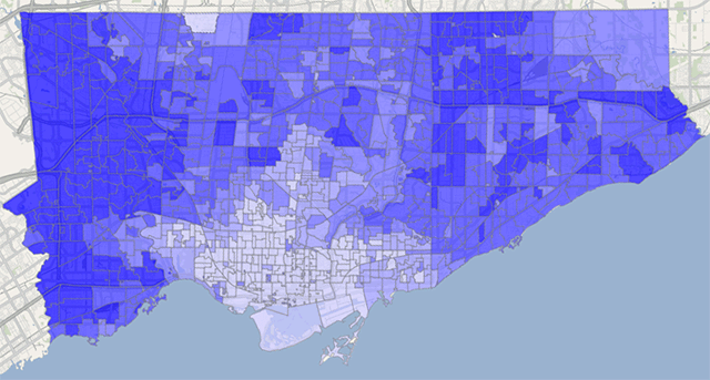
Percentage of mayoral votes cast for Rob Ford by poll (by Patrick Cain at patrickcain.ca), move over with mouse to superimpose Old City of Toronto boundaries

The unfortunate by-product of this strange correlation is a continued, and perhaps increasing animosity between the inner-city and the inner-suburbs. One is always blaming the other for forcing upon them the policies and direction representative of the politics of the “other”, pointing out how politically (and I think we can venture culturally, though not in the multicultural kind of sense) different and divided the two parts of the city really are. This fundamentally calls into question the wisdom (or perhaps, the true intent) of amalgamation. Given the choice, Toronto’s “inner-suburbs” would probably vote for Hazel McCallion if they only could, and perhaps the inner-suburbs should have been amalgamated with all the adjoining suburban areas that have a similar mindset, leaving the old City of Toronto alone at the centre, pursuing its bohemian, “crazy”, socialist, leftist (or simply centrist) path. After all, the City of Vancouver has hardly suffered by maintaining its old boundaries, and if anything has had a creeping, positive effect on the surrounding suburban municipalities, enncouraging them to progress on their own, little by little, at their own pace.

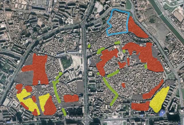
Image 01Image 01

Progress of Demolition of Kashgar

Google Earth mapping of demolition of Kashgar by Stefan Geens (ogleearth.com), click for larger version

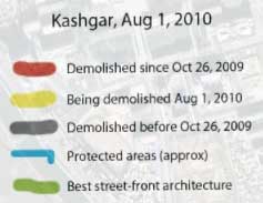
Last year warnings were raised around the world about the impending demolition of most of the ancient old quarter of Kashgar, a key city along the fabled Silk Road caravan route between west and east, located in China’s Xinjiang province (aka Uyghur Autonomous Region) near the westernmost border of China. Before demolition started, the city was considered “the best-preserved example of a traditional Islamic city to be found anywhere in central Asia.” The government plans to demolish 85% of the old town, replacing the old buildings and fabric with modern housing and development “in local style”, ostensibly to improve the local economy and living standards of residents, and ensuring housing can withstand an earthquake, though whether those are just convenient excuses is subject to a lot of discussion that I’d rather not get into. Stefan Geen (of “neogeo” website ogleearth.com) made a trip to Kashgar in late July 2010 and thoroughly documented the extent of demolition as of August 1, 2010 in Google Earth and on his website, and extensively photographed what remains and the people he met there, all mapped and located in his KMZ file for Google Earth (which you should check out for full interactivity). Above is his map of what has been demolished, and what was in the process of being demolished while he was there, as well as showing the small area that will be preserved for your typical Chinese tourist trap.

While the overall effect so far from the air perhaps doesn’t seem as shocking as the demolition of Tianjin’s old town I wrote about earlier (without more uptodate airphotos, the destruction is not yet obvious, the base is the latest Google Earth has, from October 26, 2009), the damage to the cultural heritage and tourism prospects of Kashgar will certainly be far, far worse once demolition is completed. It is frankly shocking that Kashgar was not made a UNESCO World Heritage Site, something that would have certainly at least preserved the physical character of the old town, and is an incredibly popular route for Chinese heritage tourism spots these days (China has the 3rd highest number of World Heritage Sites in the world, and growing). Of course, the country itself has to nominate the place to become designated a World Heritage Site, which likely explains why Kashgar has never been designated. While being designated is not some kind of magical panacea of preservation (leading as it almost inevitably does to massive tourism and the changes of ownership, character and development that brings with it), the degree of preservation that does occur, whether through international or financial pressures from UNESCO, can be gauged by the fact that only 2 World Heritage sites have ever been delisted for destroying the character that led to designation.

In any case, I was hoping to make it to Kashgar to experience its unique ancient character before demolition, but not sure I’ll make it now (the disturbances in Xinjiang last year didn’t help). Actually, I just came back from Shangri-La (or at least, the self-named Shangri-La which is not the same thing at all, with a stop in Lijiang, another World Heritage Site), which ironically, despite the name, is a far cry from the unique, isolated kind of place that I imagine Kashgar is (or is that was?).

Image 01