Gardiner’s No Innocent
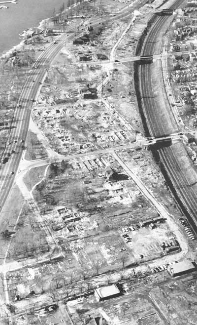
The demolition of South Parkdale circa 1956 to make way for the Gardiner Expressway, from Mike Filey’s “A Toronto Album 2: More Glimpses of the City That Was.” In Filey’s sanguine words:
“One minor problem associated with building the new highway was the need to demolish approximately 150 houses in the south Parkdale part of town – oh well.”
Oh well? For comparison, there are 262 homes currently on the Toronto Islands. The most striking thing you might notice about this stunning photograph is how the neighbourhood of south parkdale directly faced and related to the western waterfront across Lakeshore Boulevard – something almost unrecognizable along the western waterfront today since the area was excavated to build this section of the Gardiner. Note too the frequency and intimacy of the bridges crossing the railway corridor – a level of waterfront connectivity totally lost upon redevelopment and demolition (edit: a commenter pointed out that all 3 bridges in the photo still exist, it just seems like they knit the two sides together better because in the photo they do not end up at on ramps, highways and empty leftover green space as they do today).
Most interesting of all though, is how a whole neighbourhood like this can disappear without a trace. Were it not for Mr. Filey’s book, I would never have known, not being old enough to remember a different Toronto waterfront. In all the hubbub about the work of the TWRC and the revitalization of the Toronto waterfront, it’s worth remembering that we had a great waterfront once upon a time, and systematically, with cruel logic, we threw it all away. May we remember our lesson, and not let it happen again.

4 Comments so far
Leave a comment
Shit man, that sucks!
By Ben on 12.22.06 12:10 pm
Wow – I own a house at the top of the railway embankment in S. Parkdale and have often wondered how it used to look.
By Bob on 04.24.07 6:49 pm
I have lived within a stone’s throw of the area depicted by this photo for over two decades and have often wondered what it looked like before the demolition. I would point out though that the three bridges shown in this picture all still exist (Dunn, Jameson and Dowling Streets).
By wil on 10.25.12 11:28 pm
This picture depicts a pretty desolate and isolated neighbourhood…not much of a loss in my opinion. Despite being an advocate for transit and walkable neighbourhoods I have always loved the Gardiner. The highway allows those entering the city to have a comprehensible image of the downtown. Driving into the city via the Gardener is imo the nicest approach, followed by the DVP…both allow nice views of the natural and built features of the city.
By Nate on 12.19.13 1:24 am
Leave a comment
Line and paragraph breaks automatic, e-mail address never displayed, HTML allowed:
<a href="" title=""> <abbr title=""> <acronym title=""> <b> <blockquote cite=""> <cite> <code> <del datetime=""> <em> <i> <q cite=""> <s> <strike> <strong>