VirtualCity.ca delivers the real thing
Readers of the Globe & Mail might have come across a reference to this amazing new site in last Friday’s Globe Review supplement – in case you missed it, I’m pleased to clue you in to something that will soon become indispensible and boundlessly useful for any city. The article by Ivor Tossell called “VirtualCity delivers the real thing” can be accessed (for now) here.
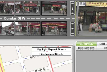
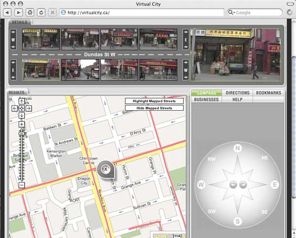
In short, virtualcity.ca has matched continuous photography of the entire streetscapes (primarily storefronts) of most of Toronto’s main streets to a google maps mapping system. All of a sudden, instead of the anonymous satellite photography of google maps, you can find exact views of the street corner you want to meet someone on, the restaurant you want to dine at, the apartment you’re on your way to see, etc. It’s amazing and near unbelievable. In fact, you can type in an address and find streetscape photography of it immediately. The site creators are working on adding residential streets to the system as well and a site for Montreal is in the works! Thank God for the internet! In Mr. Tossell’s nice words:
VirtualCity’s photos are more like day-in-the-life snapshots. Pedestrians walk the sidewalks. Streetcars and fire trucks obscure edges of the frame. You can see the detritus on front porches, recycling in the alleys, cars parked on the margins and the tail ends of streetcars retreating out of view. It’s a celebration of the urban mundane…
In trying to render a business service, VirtualCity has made a documentary of our streets that’s dispassionate, yet totally intimate. Indeed, the site is misnamed: It promises a virtual city, yet delivers the real thing, unadorned, grimy, on a lousy day, with fire trucks getting in the way of the camera.
And best of all by clicking on the top-right larger version of the active image you can view or download very high resolution images so that you can read store signage, check out street numbers or any number of things. I’m sold.

3 Comments so far
Leave a comment
[…] The Windows Live Local Preview ups the ante on the previously reported VirtualCity.ca (see post on Virtual City here). The Live Local Preview is only available for Seattle and San Francisco thus far, but the service (perhaps less practical than VirtualCity’s) has distinct experiential advantages. Instead of the side-on streetscape views focussed on the built form and shops, the Live Local Preview gives an experiential view down the street, with smaller views to left and right – and you can also essentially walk your way around with the detailed airphoto serving as a map. As you move location, the view changes relatively smoothly, essentially resembling video footage or a photo sequence of your walk. If you don’t choose “Walk” from the drop down window, you end up confined behind a car’s steering wheel looking through the windshield (boring!). Switch to “Street” view on the airphoto and you’re given the streetscape on either side as a continuous photomontage (if you’re zoomed in close enough), but it’s a bit small and couldn’t get it zoomed in any further. Using the mouse wheel lets you zoom in and out. On my Mac the interface was still a little clunky and unresponsive, but being a Windows release no doubt it’s optimized for Internet Explorer. […]
By Bricoleurbanism » Windows Live Local Preview ups the ante on VirtualCity on 11.29.06 2:23 pm
what happened to virtual city it doesnt work anymore
By mark on 02.15.09 12:01 pm
I cant seem to view the virtual city anymore. before I could zoom in on different street, but now I can’t. What happened? thanks
By lovelyonelady on 04.05.09 8:06 pm
Leave a comment
Line and paragraph breaks automatic, e-mail address never displayed, HTML allowed:
<a href="" title=""> <abbr title=""> <acronym title=""> <b> <blockquote cite=""> <cite> <code> <del datetime=""> <em> <i> <q cite=""> <s> <strike> <strong>