urbanism – landscape – ideas – theory – whimsy

Toronto’s Future Waterfront a la West 8 / DTAH

Some evocative renderings by Toronto Landscape Architecture and Urban Design firm du Toit Allsopp Hillier from the winning proposal in Toronto’s Waterfront Innovative Design Competition. Congratulations to the West 8 / DTAH team.

I reported on the result (with more images from the scheme) and set myself a-musing on its possibilities in a post yesterday. Click images to enlarge! Enjoy.

Waterfront Promenade - The Green Foot

Queen's Quay - Day View

Queen's Quay - Night View

Shaw & Yarmouth – a second shot

So here’s another photo of the little heightening project at Shaw & Yarmouth shown from the side in the last post (Development in Toronto Part IV – Heightening). I don’t know if it’s a much better photo, but you can more clearly see the extra storey in comparison to the left-hand part of the building.

For those familiar with Shaw Street, you’ll recognize this little gem just further south on the same block. Nothing like a little variety added to the nondescript streetscape!

Development in Toronto Part IV – Heightening

Urban Designers have been waiting for it for ages – and it’s finally here. Heightening. The continuing strength of Toronto’s main streets fuelled by a slowly crawling gentrification has led owners in some districts to realise the potential of their buildings themselves instead of selling out and moving on. The consequence is less main street blockbusting with 10 and 20 story condo monsters with underground parking and more renovations of main street buildings – part of which is heightening, adding a floor or two to your existing building.

Now if only the same attitude would become more pervasive amongst the reams of single family homes that make up the majority of Toronto’s neighbourhoods. Perhaps then we would see more liveable and comfortable apartment units instead of the endless stream of awkwardly renovated houses uncomfortably filling the gap between high rise condo and unattainable single family house.

The current heightening hotspot is College Street west of Ossington, which I believe is a largely Portuguese community but is definitely an emerging hotspot of activity, though less centred around the arts as Queen West West.


Development in Toronto Part III – Inglis Lands

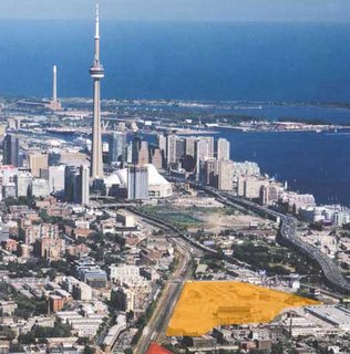
I’ve seen this project variously named King Liberty, East Liberty Village and Inglis Lands. It is “a 45-acre brownfield site located in the King Street West / Strachan Avenue area, immediately west of downtown Toronto.” The Inglis plant had been on this site off Strachan Avenue since 1881, employing at its peak 17,800 people during the second world war. The company started out building equipment for grist and flour mills, then marine steam engines and waterworks pumping engines, guns for the war effort, then consumer products after the war, including house trailers, oil burner pumps and domestic heaters and stoves, finally adding home laundry products and other home appliances for which Inglis became well known. The closure of the Strachan Inglis plant (affecting 650 employees) was announced one month after the Canada-US Free Trade agreement came into effect in 1989, and 2 years after American giant Whirlpool took a controlling stake in the company.

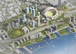
“The redevelopment of this site is seen as a major opportunity to create a significant new residential neighbourhood and associated employment space providing important “live-work” opportunities. Situated in the northern portion of the Garrison Common area, immediately north of Exhibition Place, these lands will play a strategic role in achieving City of Toronto policies related to residential intensification as well as embracing various smart growth initiatives. Specifically, this mixed-use development will offer this growing community new retail, office and high-tech type users.” (from IBI Group promotional material)


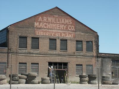
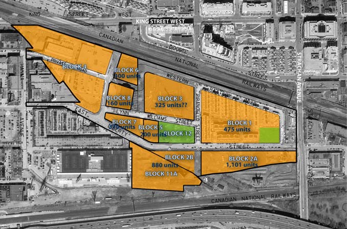
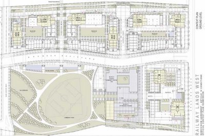
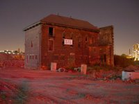
Historic buildings that will remain are in Block 12 (the central park) and Block 8. Both have connections to the old Central Prison for Men which was on this site from 1873 to 1915. The building in the park (Block 12) contains the Chapel of the Prison, is historically listed, and will be preserved as part of the park – though that probably means having a Starbucks put in. The building on Block 8 is the Liberty Storage Warehouse also known as the A. R. Williams Machinery Building at 130 East Liberty Street. This building contains part of the paint shop of the prison dating from circa 1879 – however, despite being historically listed, 
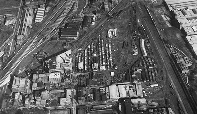
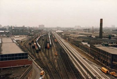
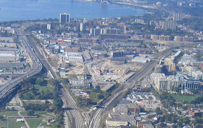
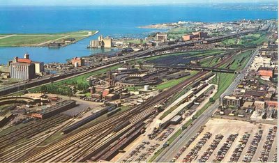
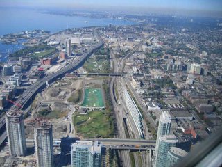
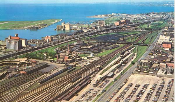
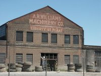
with many of the features of the warehouse itself (which was completed in 1929) appearing in the listing, only the southern 28m of the building will be “saved” with a 52m tower allowed to occupy the rest of the building’s footprint. The northern portion of the site was a small railway freight yard (which can be seen in the top left of the 1935 aerial photo above – north is to the left with the Exhibition Place buildings to the extreme right). The photo below is from Strachan looking west with the Inglis Plant on the left, the freight yard beyond and the Massey-Harris complex to the right. Pretty much everything in this photo is gone today except for the main railway lines.


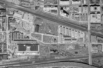
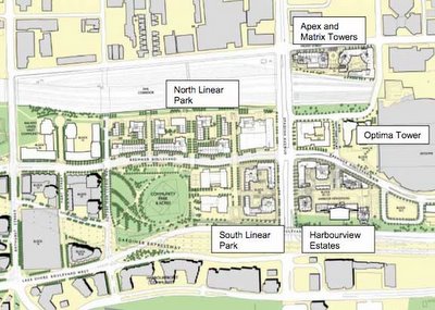
Phase 1 was the stacked townhouse development on Block 1 (that can be seen in the 2005 airphoto above) and which is now completed. These stacked towns are basically masquerading as live-work units – but whether any effort has been made to make them flexible enough to truly be live-work is questionable. I personally don’t believe this building type was appropriate; their tight ranking in rows along narrow private (sometimes pedestrian) “streets” does a poor job at promoting a good mixed-use urban image in the area and in really framing the street the way a mixed use apartment building can. To top it off, stacked townhouses in Toronto are just plain ugly most of the time – trying to look like a house but at the density of an apartment building. The marketing behind them is relatively straight-forward though – in Toronto, units with their own ground-level entrances will sell no matter where they are. Note how not a single front facade faces the small park/square on Block 1. This is not quality urban design – despite winning a Canadian Urban Institute “Brownie” award in 2005.

Phase 2 is currently under construction on Block 3 under the name “Liberty Towers” – a 24 storey building with 276 units – it’s a little unclear what else might be on that block though, so my figure of 325 units may or may not be more accurate.

Despite having a 35m height limit, Block 4 was immediately developed as a big-box Dominion supermarket with a large parking lot and a small strip mall – all one-storey. I’d classify that as embarrassing given the location, but I believe the zoning at that end precluded any residential units being built on Block 4.

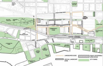
We’ll see how this one pans out – there’s a chance that once the really dense buildings get in there, they’ll have found a way to save this thing. I’m worried about it though – especially from the perspective of connecivity. Directly to the north on the Massey-Harris lands there was a mixture of ugliness, misdirectedness, and beautiful moments – so lets hope some of these future phases save this area’s ass and that they do a good job on the central park and the rest of the buildings.

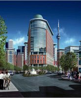
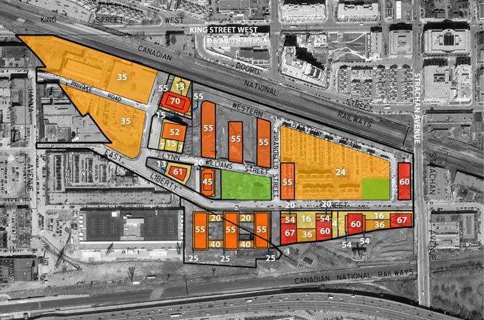
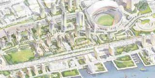
This image from IBI Group seems highly optimistic to me and possibly quite deceptive – I can only assume this is meant to be Block 7 looking east, but this building is now allowed to have a c. 4 storey (13m) podium and a c. 20 storey (61m) tower and will very doubtfully be such a “flatiron” signature building (it no longer appears to be so far forward on the block to create the wedge shape). The entire area is still very isolated, especially now that the Front Street Extension appears to be on hold yet again – and I haven’t found anything indicating concrete plans to improve this isolation. I also don’t think that there is enough real urban fabric here to make it a place that could stand on its own.

Railway Lands Update – Landscape Architecture Against the Ropes?

For a while it’s seemed like Landscape Architects have been increasingly relegated to subservient roles in many areas of their work outside of their core discipline of designing and overseeing construction of built landscapes. Sometimes, hard as it can be to admit, willingness to accept these roles has become a justification for this trend – references to Landscape Architects as simply putting trees and green on plans are saddening largely because of how frequently they are true. However, recent events in the Railway Lands in Toronto have highlighted the ongoing battle over Landscape Architecture’s home turf.

In some ways the momentum of design initiative itself – particularly in the urban environment – has been slipping away from Landscape Architects for some time. Whether it’s because outsiders have much fresher perspectives on the issues of landscape architecture, or overly pragmatic professional associations solidifying mediocre standards and approaches as “best practices”, or a fault in landscape architectural design education, designers without an affiliation to landscape architecture have been successfully winning many large and significant projects within the core discipline of the landscape architecture profession.

From Downsview Park‘s winning design (by Bruce Mau and Rem Koolhaas) to Dundas Square‘s controversial slickness (by Brown + Storey), landscape architects are becoming simply a required member of a team led by an architecture firm for many of the biggest landscape architectural projects in Toronto.

And now, enter some new competition. Douglas Coupland, the author and artist who “coined the term ‘Generation X’ with his book of the same name” has been “hired to design a three-hectare park” in Toronto, according to press reports released last week. The park in question is the new community park required to supplement Concord Adex’s mammoth CityPlace development in the West and Central Railway Lands. The headlines were euphoric: “Impassioned Canadian artist, Douglas Coupland, commissioned to design eight-acre urban park at Concord CityPlace”, “Coupland’s Toboggan Vision”. The Globe and Mail was more realistic – “Author Coupland to help design park”.

Never mind that the press reports are slightly inaccurate. Never mind that Coupland is in effect the artist selected for the City’s public art requirement, was selected independently of the search for a landscape architecture team, and is intended to be “working in tandem with the landscape architect.” Never mind that as far as I can tell that means that the Landscape Architect will be designing the park – and that means Greg Smallenberg of well-regarded Vancouver firm Phillips Farevaag Smallenberg, aided in Toronto by David Leinster of The Planning Partnership.

Is there something about landscape architects that makes them so much more unglamorous than other potential designers? Is there something that makes them unworthy of having the headline even when it’s one of the most significant privately-funded landscape architecture projects in the city in decades? Maybe landscape architects these days lack the vision of other designers or don’t have the same authoritative way of capturing the imagination of the public. Is it landscape architects who have lost their imagination? Let’s face it – they must be doing something wrong if everyone accepts that an artist is needed to create a great park, or that a landscape architect can’t be trusted to come up with a fresh, imaginative and interesting concept.

While on one hand I’m hurt by this attitude towards landscape architects, part of me knows and admits that the profession in Canada does desperately need some freshening up – both in imagination and authority. There are landscape architects doing great, interesting work – from built to theoretical – but we must start to accept that we can no longer take for granted our role as key designers in our core discipline. Just as landscape architects need to fight for their roles at larger scales and at the periphery of the discipline by competition and equivalence with others working in those areas, so they must join the fight in defending their own backyard so to speak – the future of design seems to be the need of designers to prove both their role and their worth regardless of professional affiliation. And the kind of self-examination and re-examination of core principles that this would require may be just what the landscape architectural profession needs.

Development in Toronto Part II – West End Update

You do not want to know how long it took to get all this mapping and unit #s together. I’d call that an example of how useless the City is at presenting a comprehensive view of what’s going on. This map is from just east of Bathurst to just west of Dufferin, from the waterfront up to north of Queen. Click it to enlarge and see the number of units for many of the completed, under-construction and proposed developments in this very rapidly changing area. Some figures are estimates (with ? beside).

Development in Toronto Part I – Railway Lands


Ever get really pissed off trying to find out what the hell is going on (development-wise) in one of Toronto’s several large development projects? We’re talking showcase large scale urban brownfield sites, the likes of which – once developed – we will rarely see again, such as the Massey-Harris/Ferguson lands, the Inglis lands, and the Railway lands (shown above before the yards, and western roundhouse were removed). Now, you might think that a simple visit to the City of Toronto’s website would clarify the matter – especially for a location as fundamentally important as the railway lands. Perhaps the Planning Department would give us a clue? Nope. Do a search for Railway Lands. Aha! So here we have the Urban Design Guidelines for the Central/West Railway Lands (but just try getting there from the Urban Design page). But of course, urban design guidelines are a relatively toothless mechanism to control development (something that’s being addressed with recent proposed changes to the Planning Act, Municipal Act, Provincial Policy Statement, and Ontario Municipal Board, see Ministry of Municipal Affairs and Housing who do a great job at clearly explaining all of their work) so how do we know that what they show is what we’ll get?

Now we all know that there are comprehensive plans done for all these areas just so the developers can ever get approval. At some point no doubt there were public meetings at which the plans were shown – but where the hell are these things now? Shouldn’t people be able to see the shape of the city to come, even if they didn’t happen to be at the one or two public meetings? Wouldn’t it be helpful, informative, and simply good public policy to keep the citizens of Toronto aware and on-board – especially when the projects are large to the point of being virtually sensational? Isn’t this where the dialogue about how to make a good city, how to grow responsibly and in a way that adds to the quality of the city, should be taking place? Maybe the developers don’t want anyone to know their detailed plans? Maybe noone thinks that anyone cares once all the planning’s done? Think again.

Given the disappointing results of the first phase of CityPlace (Central Railway Lands) one would think the City would be at pains to be more up front about what’s happening. On the other hand, you would think that they would be delighted to be giving out information on successful large scale development on important sites in the city. Sure the CityPlace: Railway Lands West Public Realm Master Plan, Architectural Guidelines and Implementation Plan got an honourable mention at the 2005 city urban design awards in the visions and master plans category (see here, but the real question is, did it deserve it) – but wouldn’t it be nice if uptodate information about the detailed design of this stuff as it will actually be built was continually available? It could be that I’m just slow and can’t find the information that is plainly on the City’s website. Just in case anyone else has the same trouble as me – here’s a few snapshots of what to expect in the West Railway Lands. If you don’t read plans well, or can’t picture what’s going on – tough. I challenge you to find anything better – and secretly hope you do! The two 3d images below are probably well out of date. In the detailed plan below, the block directly east (to the right) of the community park will house public schools (public and separate) and a community centre/daycare (all up against the east-west street, Fort York Boulevard). South (below) the schools buiding is an “affordable housing” complex which appears to be peculiarly isolated from all public right of ways, serviced by what looks like a private road. Why on earth we are we still building affordable housing in isolated separate buildings? Why can’t units of affordable housing be distributed individually in market-rate buildings the way it is proposed to be done in Regent Park? Anyways, somehow it all looks a little thin on the ground to me – especially for a site that on the whole particularly suffers from a physical isolation from the rest of the city, jammed as it is between the railway corridor and the Gardiner Expressway.


Tired of all those development notices?

I came across this appropriation of a development notice a while ago and only just found the photo again. It was somewhere in downtown Toronto but I can’t remember where, and have no idea who committed this clever act of subversion (though suspect some of the people over at the public space committee or spacing might know something about it).

Not that I have anything against development. I guess I have something against the way it happens and the kinds of buildings that get built – and sometimes the kinds of buildings that get torn down to make it happen – but most of the time I’m just hoping the current building boom will last long enough for Toronto to get rid of a few more of the surface parking lots that still dot the downtown – one of the most offensive reminders of the ridiculous nature of development economics (since all of them would have had buildings on them, now long demolished because surface parking is so damn profitable).