urbanism – landscape – ideas – theory – whimsy

GTA population grows by 9.2% since 2001

statcan_toronto_cma.jpg

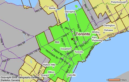
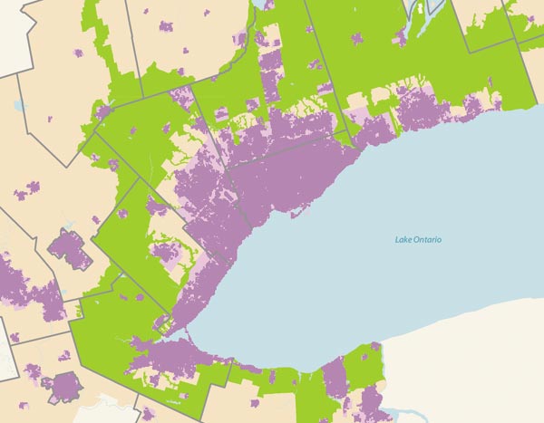
Statistics Canada has started to release data from the 2006 census at the City level – including population figures for Toronto and the GTA (or at least the Toronto Census Metropolitan Area (CMA), mapped above). By this measure, the GTA has grown 9.2% since 2001, with a population of 5,113,149 – that’s an increase in population of 430,252 in five years. The City of Toronto itself accounted for only 21,787 of this increase (with a very modest growth rate of 0.9%, and despite what most of us would think of as a significant high-density condo boom) which gives you an idea of the massive pressure on land development at the edges of the city.

To put that in perspective, the increase is equivalent to adding the entire Kitchener CMA (which includes Kitchener-Waterloo and Cambridge)(451,235), or the entire London (ON) CMA (457,720) to the GTA in the last five years. That’s very nearly the entire population of Newfoundland and Labrador (505,469), and eerily near the population of the City (not CMA) of Vancouver (578,041).

This only emphasizes the critical importance of GTA-wide planning along the lines of the Places to Grow work being done by the Province, but also makes one wonder where this type of planning was 10 or 20 years ago when we really needed it. If this kind of growth keeps up, the Provincial target to have 40% of new residential units inside the current urban boundaries is going to be a real challenge.

Lower Don Vision – bricoleurbanism style

lowerdon_bricoleurbanismorg_crop2.jpg

The TWRC recently put out a call to Torontonians for visions for the Lower Don Lands and the mouth of the Don River (see here), perhaps as a consolation for the closed, restrictive process they seem intent on following for their “Innovative Design Competition for Toronto’s Lower Don Lands” for which they released a shortlist on 2 February (see here).

Maybe they thought that the Innovative Design Competition for the Central Waterfront (see here) was so successful, they figured they’d just do the same thing over again. At least it’s clear that they’re intent on moving forward with winning schemes into implementation, which is not always the case.

But starting off with an RFP process is hardly a way to get the maximum number of people involved. While they say that they’re “seeking input from the world’s most talented and creative design and engineering professionals in developing bold new concepts for the Lower Don Lands area”, it hardly seems likely that the world’s most talented and creative people have been boiled down to the 5 shortlisted teams. The proposals themselves are never released publicly, only the finalists’ entries are, so at best we get 5 concepts to publicly review and have to rely on the wisdom of the shortlisting process to have chosen teams that might produce the most innovative design responses.

While the process obviously can work (quite a bit of attention was generated with the Central Waterfront competition), it does have drawbacks – the winning team for the Central Waterfront (West8/DTAH) was a clear winner since most people were less than impressed by the other teams’ submissions. The fact that the Nathan Phillips Square competition (see here) is being run in the same way, makes it clear that a wide spectrum of ideas is not what public agencies in Toronto are really after.

Which leaves some designers and Torontonians (either those not shortlisted, or ineligible to compete by virtue of not being on a team with all the requirements demanded by the RFP) shit out of luck. Cue the “Submit Your Vision for Toronto’s Lower Don Lands”. However, being limited to a single double-sided letter sized page is certainly unusual for most designers, so it’s obvious that they really are looking for the ideas of the average Torontonian.

And as for design students, who traditionally are keen submitters to competitions (if only because their studios are often based on a current competition), whatever ideas they may have come up with, they’d better fit on that double-sided page too.

So, even if only to get the ball rolling and get some ideas out in public (where’s the TWRC going to hide all the visions submitted by Joe Public?), bricoleurbanism.org is proud to here present our vision for the Lower Don Lands. Click on the images to view the full drawings.

lowerdon_bricoleurbanismorg_crop4.jpg

Mapping Our Urbanism Part III – Water Mains

to_watermains_early2_e.jpg

In the Toronto Star last weekend was a special 2-page spread on the sorry state of Toronto’s water mains with emphasis on who’s to pay for upgrades (see story online here). However, the maps included give a fascinating glimpse into the history of Toronto’s development seen through the age of the water mains. Divided into four periods, 1859-1900, 1901-1940, 1941-1960, and 1961-2000, these maps are indispensable for anyone interested in the history of urban infrastructure. To see a little more detail, follow these links (maps 1+2, maps 3+4) – if you prefer a much more detailed PDF version of the maps is available from the Star’s site here (PDF).

to_watermains_modern2_e.jpg

Crossposted to the Spacing Wire

Planning in Ontario – Part I: The OMB

With all the bad blood that the Queen West Triangle planning and OMB extravaganza has created in Toronto (see Active 18, spacingwire posts here, Reading Toronto here), it’s worth reflecting on the true nature of planning in Ontario.

Anyone familiar with the Ontario Municipal Board (OMB) process will know that the “Board” is in fact essentially a kind of court (dare we say kangaroo court?), where land use planning disputes are frequently heard when someone doesn’t like the decision made by the municipal planners or politicians. The process really boils down to lawyers arguing before a judge, using “experts” from the professions as both hired witnesses and fabricators of “evidence”. Anyone who thinks that that sounds a little strange must be new to the bizarre world of planning in Ontario.

In the spirit of openness that our planning system should be engendering, let’s get some help from Ambrose Bierce’s wonderful century-old Devil’s Dictionary for some enlightenment on the process (an online version of the dictionary is wideley available as copyright has expired, try here).

Bierce defined a lawyer as:

LAWYER, n. One skilled in circumvention of the law.

Who better to be in control of key planning decisions in Ontario?

But wait, there’s more!

The profession of planning in Ontario seems to be held in such poor esteem by the populace that despite widespread disgust with the OMB and its (perceived) pro-development decisions, there seems to be minimal support for planners having any more control over planning either! Who needs those silly professions after all?

Luckily, Bierce can help us out again to clarify what planners are trying to do in the first place.

Bierce defined to plan as:

PLAN, v.t. To bother about the best method of accomplishing an accidental result.

Sound familiar?

We might go so far as to say that such a definition of plan largely applies to public planning in this province. Private (consulting) planning might be better represented by an amalgam of the two thusly:

PLANNER (PRIVATE), n. One skilled in circumvention of the plan.

Enough said! Lesson 1 of a 106 part series, “Planning in Ontario”!

“Paving” the way for a new Four Seasons

yorkville-bay-pan-f_e.jpg

A rough timelapse sequence of the demolition of the old Ford dealership on Yorkville Avenue as part of site preparations for the new Four Seasons hotel/condominium proposal which will stretch from the historic fire station (with the tower visible in the photos) west between Yorkville Avenue and Scollard Avenue to Bay Street. The yellow box in the left of the photos is the sales centre (under construction).

The proposal is for two towers, one 46 storeys at the corner of Bay and Yorkville and the other of 30 storeys on Scollard adjacent to the existing recently completed mid-rise residential building. The proposal also includes a new urban square/park to complement the one built to the east of the fire hall and Yorkville library as part of the 18 Yorkville development, along with an integrated linear connection joining the two parks behind the library and fire hall. While these drawings certainly don’t show that the new park at this point will have the panache of the one designed by JRALA, the proposal has been given City approval, but I believe it has been challenged at the OMB by community and residents groups, with a decision still to come. More info (from the City) can be found here, OMB case details here and here.

Despite the enormous amounts of money involved in such large scale developments, it’s a sobering thought that surface parking is so profitable that it’s the first thing you do while waiting for your official go-ahead.

4s_4_birdsey_view_e.jpg

4s_courtyard2_lg_e.jpg

4s_dusk_lg_e.jpg

Gardiner’s No Innocent

south-parkdale-1950s.jpg

The demolition of South Parkdale circa 1956 to make way for the Gardiner Expressway, from Mike Filey’s “A Toronto Album 2: More Glimpses of the City That Was.” In Filey’s sanguine words:

“One minor problem associated with building the new highway was the need to demolish approximately 150 houses in the south Parkdale part of town – oh well.”

Oh well? For comparison, there are 262 homes currently on the Toronto Islands. The most striking thing you might notice about this stunning photograph is how the neighbourhood of south parkdale directly faced and related to the western waterfront across Lakeshore Boulevard – something almost unrecognizable along the western waterfront today since the area was excavated to build this section of the Gardiner. Note too the frequency and intimacy of the bridges crossing the railway corridor – a level of waterfront connectivity totally lost upon redevelopment and demolition (edit: a commenter pointed out that all 3 bridges in the photo still exist, it just seems like they knit the two sides together better because in the photo they do not end up at on ramps, highways and empty leftover green space as they do today).

Most interesting of all though, is how a whole neighbourhood like this can disappear without a trace. Were it not for Mr. Filey’s book, I would never have known, not being old enough to remember a different Toronto waterfront. In all the hubbub about the work of the TWRC and the revitalization of the Toronto waterfront, it’s worth remembering that we had a great waterfront once upon a time, and systematically, with cruel logic, we threw it all away. May we remember our lesson, and not let it happen again.

Mapping Our Urbanism Part II – Extents

ggh-growth-areas_det-e.jpg

The Ontario Government’s revolution of planning in this province continues to move forward. The Places to Grow initiative (Growth Plan for the Greater Golden Horseshoe, see here) has been given a benchmark by a Technical Paper on a Proposed Methodology for Developing a Built Boundary for the Greater Golden Horseshoe, “an important component for monitoring the implementation of the Growth Plan” (see here). Essentially, what has been created is the most uptodate database of the current extents of development in the GGH (and by extension, the GTA). Knowing the current extents of development is crucial to being able to evaluate progress on the stringent intensification requirements demanded by Places to Grow and the implementation of the greenbelt.

What’s great for the purposes of mapping our urbanism is that these maps (excerpted from the new Technical Paper) give us an accurate and uptodate view of the extents of the city and greater region as it is essentially right now, and also how the extents of current development fit into the protected land of the greenbelt. This is quite a unique view of things, and one that is much clearer to read than a satellite photo.

ggh-growth-areas2e.jpg

Development in Toronto Part VI – Gateism

282_8244_e.JPG

I’ve been noticing an increase in “gateism” along the residential streets of Toronto. While they say that “good fences make good neighbours”, there’s something about fences that are higher and more robust than seems necessary that leads to a few worries. Fences alone are one thing – they do a great job of defining space and ownership and are an easy way to quickly read the definition between public and private urban space – while without gates they can also be penetrated with ease. Gates on the other hand, are more worrying. The gate doesn’t rely on subtle hints to define public and private, but demands compliance through a physical barrier. Usually, one would assume a gate is either intended to keep something in or keep something out. If these gates and fences are being erected to keep dogs in I would be very surprised. If they are in response to some perception of a threat from the general public, it suggests a worrying trend for this city’s public space.

In countries such as England, gateism as a response to perceived security threats from public space have led to broken glass and barbed wire on the tops of walls, and no side passage left ungated. Increasing numbers of houses in Toronto seem to be gating their side alleys in a city where there used to be a relative permeability between front yard and back. On the other hand, increasing densities and busier street and foot traffic demand responses to maintain the privacy, security and serenity of the urban home. This current form of gateism does not seem to be desirable, but it’s obvious that people are expressing a desire for more privacy than the typical form of the city and its open front yards is supplying. The city should be encouraging more creative and beautiful solutions that rely less on the aesthetic of the security perimeter and more on an integrated landscape strategy. In the meantime, we will probably have to get used to a streetscape defined less by semi-private overlooking porches, and more by visually impermeable fences, hedges and gates.

282_8233_e.JPG

Drakespawn

westsidelofts-queenw

The influence of the Drake Hotel continues. Whichever side of the issue you fall on, you can’t argue with the results – changes along Queen West between Ossington and Dufferin have been both pronounced and rapid, from cafes and bars to boutiques and Starbucks.

Those changes are just the tip of the iceberg – a couple of significant condominium development proposals are currently in negotiation south of the Drake in the area dubbed the West Queen West Triangle – and this bizarre sales centre for the “West Side Lofts” (stuck right beside Woolfitts) is the harbringer of things to come.

While it’s exciting that they’ve broken with the staid and obviously temporary standard typology of the sales centre, the flip side is that the aestheticisation of architecture and design in this case is entirely for the sake of attracting attention in the form of sales – once that function has been fulfilled, the building will disappear. This seems a more and more common “programme” of contemporary architecture (read ROM, AGO), one which almost of necessity neglects the other responsibilities of buildings towards the urban fabric.

I suspect that the debate over the influence of the Drake and the nature of gentrification along Queen West is just getting started.

Development in Toronto Part V – Simulacra

lowther-old

lowther-new

I could have used any number of examples in Toronto of simulacric development but this one in particular caught my eye since construction has been in process for months and months and I go past it almost every day. These two buildings are on Lowther Avenue just east of Avenue Road. The top photo is the original – an interesting semi-detached building form with covered access to the rear garages which I suppose must originally have been for coaches to access the coach houses. This form still has a few survivals – all of the ones I know are very near to this one in Yorkville, and you can almost imagine them being built at a time when Yorkville was a village a short distance north of Toronto, surrounded primarily by agricultural land and large estates.

The simulacrum is just down the street. It too appears to be two semi-detached units with a covered passage to the rear, but has an additional third storey. I can only think that the City must have given permission on condition that the building fit in, but it’s certainly rare to see an old form so religiously copied. One wonders whether the real genesis of the idea came from the developer, the architect, or the City! Unfortunately, construction’s been going on so long that I can’t remember what occupied the site before, so for all I know they tore down an unprotected historical building in order to build this.

I’m of two minds about this building actually. One side of me really appreciates the lengths they’ve gone to to reproduce an historical form that is none too common in the city and which (by virtue of “hiding” the garages round back) achieves some contemporary urban design objectives. The other side of me wonders how much money they must be selling them for given the location and the fact that they’re pretty much replacing two units where there may have been two before. Which also brings up the perpetual mysteries of real estate development economics – how can this be profitable given land values in the area? Why are small-scale apartments (even if they are condominium) seemingly so hard to develop in Toronto even where land prices are high? Lastly, I wonder if the area or street has some kind of zoning protection which effectively stops anything denser than this kind of development. But I’m too lazy to actually bother finding out, so I’ll leave it at that. If anyone knows any more about it, drop me a line.

I haven’t even touched on the real simulacric question here – does the simple reproduction of a form like this, with dressed up styrofoam detailing and faux stone wall construction really act as a stand-in for the original? Is there something missing in this kind of reproduction? The value of the historic example is to me self-evident – but given current construction techniques, will the new simulacrum ever build that kind of value over time? Or will it simply one day be replaced after all the stone and styrofoam falls off and it’s horribly out of style? I wonder.