Beautiful Urban Moments – Part IX
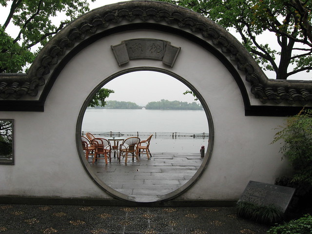
West Lake in Hangzhou, China from one of the gardens along its edge.
West Lake in Hangzhou, China from one of the gardens along its edge.

August 2008 - Band shelter and (temporary?) public space
An interesting evolutionary space has been created in the Junction on a vacant lot where some retail buildings were demolished in 2007. The empty site (which was originally being advertised as a “New Retail Development Build-to-Suit Opportunity”) was rehabilitated as an outdoor stage venue (the “Junction Train Platform”) as part of the centennial celebrations commemorating 100 years since the former City of West Toronto was incorporated. The (I think temporary) space has been outfitted with some seating and temporary plant material and seems to be a pretty popular place for people to relax and have a conversation. Behind the potted evergreens at the back I think are some parking spots. It’s a great use of what was essentially a barren, desolate gap in the urban fabric! More on the City of West Toronto Centennial celebrations, West Toronto Junction Historical Society and The Junction BIA.

August 2007 - "New Retail Development Build-to-Suit Opportunity"

March 2007 - Buildings in process of being demolished
A BBC television series called Britain From Above will be using GPS “satellite tracking and groundbreaking computer imaging” so we can “watch for the first time on television the great migrations across our landscape” that is the “unseen ballet of Britain”. This video teaser includes tracking the routes of shipping in the English Channel, taxicabs in London, tracking aircraft movements and telecommunications traffic!
Awesome!
A slightly better quality version of same video is available on the BBC’s site.
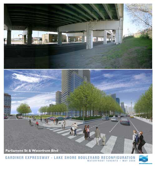
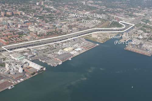
In an announcement with significant ramifications for the waterfront, the much-maligned Gardiner Expressway is to come tumbling down…. at least part of it. Waterfront Toronto, the City and the provincial Ministry of Public Infrastructure Renewal together appear to have stumbled into a momentous decision with the removal of funding for the Front St Extension and the (resulting?) decision to demolish the portion of the Gardiner from east of Jarvis to the Don Valley Parkway.
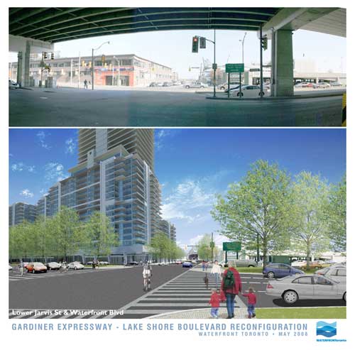
In these images released today, Waterfront Toronto gives us an idea of what the demolition of the Gardiner may mean at street level. And frankly, if this is the way it’s handled, it looks fantastic – with the added benefit (not shown in the renderings) that the railway corridor is not as wide by the time it gets to Jarvis, meaning there could be a window of hope for a relatively pleasant passage down to the lake for the East Side, all of a sudden making Waterfront Toronto’s proposed developments at West Don Lands, East Bayfront and in the future at the portlands, seem far more connected and potentially vibrant. Could this be a great day in the history of Toronto’s waterfront?
Hold your horses there…. I’m not so sure. While clearly this is a decision many of us have been gagging for for years (nay, decades!), in typical Toronto fashion are we bollocking up one of the most important decisions in the city’s planning history? While the renderings show a relatively tamed boulevard at grade (along the lines of University Avenue perhaps), the plan almost seems a slap in the face to the functionality of the Don Valley Parkway and the Gardiner combined. Now in a way it’s great that expressway functionality is not determining the decision making here, but this decision has huge ramifications on two very important roads that currently connect and essentially function as one road. While many will say “who cares”, what exactly are the expected traffic volumes on this at-grade road and how tamed and crossable will this really make it? I mean if it’s essentially a Gardiner at grade with a pedestrian signal every 5 minutes, I’m not so sure this is a good thing.
But apart from that, the mind-boggling, ridiculous, tear-you-hair-out frustration of this scheme is that if you’re making such a mess of the Gardiner and its “flow”, doesn’t it just make sense to demolish the whole damn thing while you’re at it (at least make it part of the plan to do so!)? Why on earth should the Gardiner remain above grade as it crosses the foot of Yonge Street, the most important damn street in the City and the Province, and come down at Jarvis? If you’re screwing up the Gardiner anyway, and the projected volumes are nice enough to cross at grade, then bring the whole damn thing to grade out at Strachan and open up Fort York to the lake, give City Place a chance to be an actual place, and dish out the benefits to the whole central waterfront while you’re at it.
But no. Just like Toronto to do something like this half-assed and (surprise, surprise) solely for the benefit of Waterfront Toronto’s proposed developments alone. Message delivered: central waterfront, go f**k yourself!
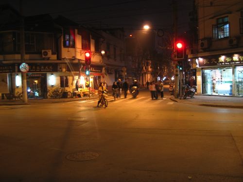
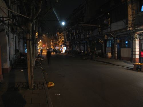
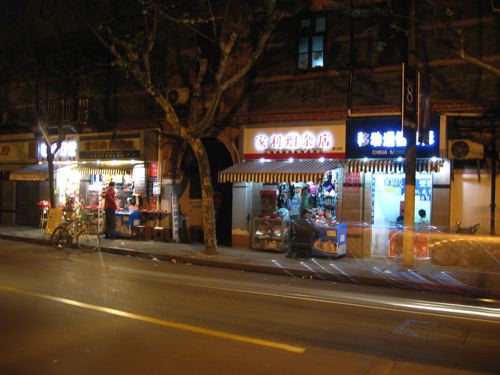
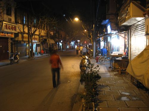
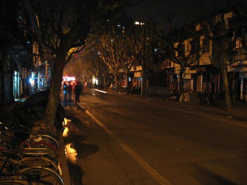
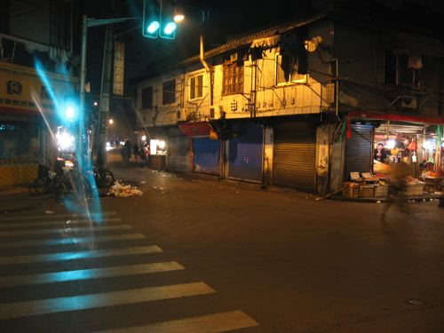
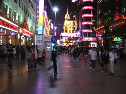
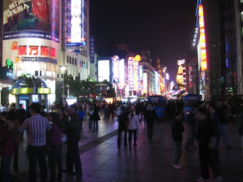
Just back from a trip to Shanghai, a beautiful (and unbelievably safe) city at night. A little taste of night life in some older districts, and at the end some night shots of the long pedestrianised part of East Nanjing Rd (Nanjing Dong Lu), “one of the world’s busiest shopping streets”.
More from Shanghai soon.

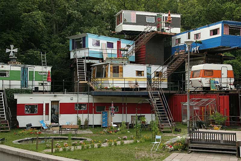
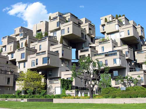
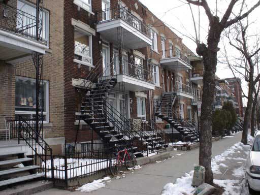
A friend sent a link to this photo entitled “Redneck Mansion”. There’s a certain genius to the way this has been done (and the colours are fantastic) – it could almost be a Bricoleur’s version of Moshe Safdie’s Habitat in Montreal (and would cost a hell of a lot less). The staircases are even reminiscent of Montreal’s exterior walkup duplexes/triplexes/multiplexes.
——————
Edit:
Unfortunately (I might say), it turns out that the intriguing caravan-sculpture masterpiece is an Amsterdam theatre set from 2005 designed by Catherina Scholten for a production of Checkov’s Ivanov. What a great idea for a theatre set! I say unfortunately because part of me dearly wished that some inspired bricoleur out there had actually dreamed up and executed such a wonderful habitat – alas no!
Here you can see some of the audience:
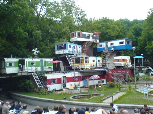
Photo: HetGelaat
The original photo posted was by Elmer Kroese.
Thanks to Space & Culture for linking to adaptivereuse.net‘s discovery of the true origin of the photo and work.
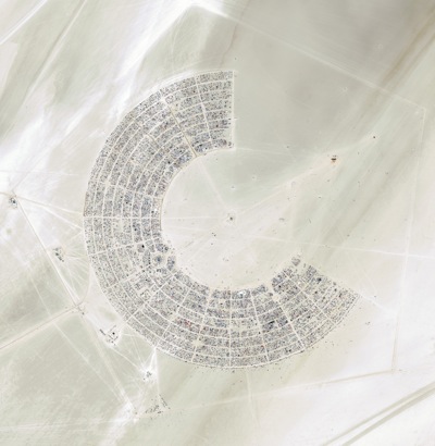
Black Rock City is the temporary city created each year to house the revelers at the 8 day Burning Man festival in the Black Rock Desert in Nevada.
From Wikipedia’s article on the subject:
“Much of the layout and general city infrastructure is constructed by Department of Public Works (DPW) volunteers…
“The developed part of the city is currently arranged as series of concentric streets in an arc composing, since 1999, two-thirds of a 1.5 mile (2.4 km) diameter circle… with the Man Sculpture and his supporting complex at the very center (40°45’56.88″N, 119°13’39.59″W in 2007). Radial streets, sometimes called Avenues, extend from the Man to the outermost circle…
“The innermost street is named the Esplanade, and the remaining streets are given names to coincide with the overall theme of the burn, and ordered in ways such as alphabetical order or stem to stern, to make them easier to recall. The radial streets are usually given a clock designation (for example, “6:00, 6:15”), in which the Man is at the center of the clock face and 12:00 is in the middle of the third of the arc lacking streets….
“Center Camp is located along the midline of Black Rock City, facing the Man at the 6:00 position on the Esplanade, and serves as a central meeting place for the entire city.”
The City is located in a slightly different location each year, and the festival itself upholds a policy of “leave no trace”. The 2007 edition of Burning Man brought together 47,097 people in an otherwise empty and desolate landscape.
Oblique (not from straight above) photos below are by Brad Templeton – plan photos are from GoogleMaps/Earth.


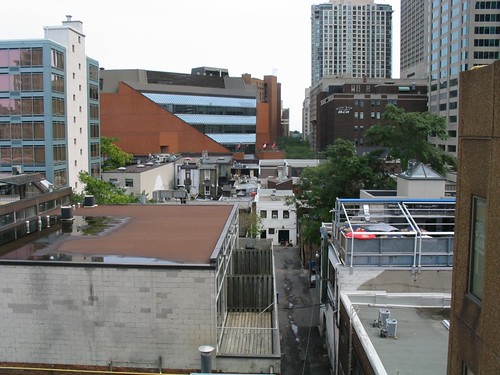
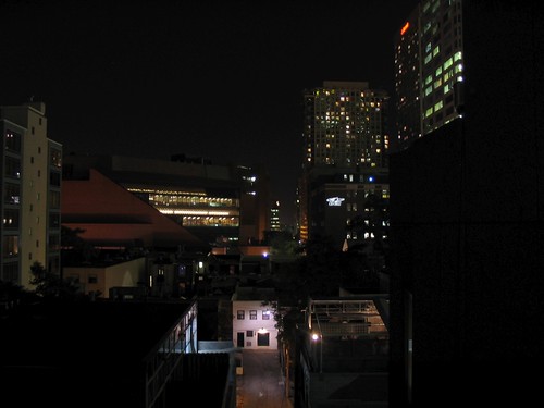
Photo (above): View east from parking garage along alley between Yorkville Ave and Cumberland St, in Yorkville west of Yonge, showing Metro Reference Library, rooftop patio of The Pilot (the Flight Deck) and other buildings in the Yonge-Bloor area, Toronto. Night view (below).
It’s that time of year again, when the TIFF turns Yorkville into a glitzier, crazier, and more bustling place than it already is. While moments of peace may be harder to find during the Festival, it’s worth reflecting for a moment on the heterogeneous beauty of the Yorkville area and how in some ways it represents the genius of Toronto’s urban character. While many people have been upset at the recent intense condo and hotel development in the area, a large number of the older, small-scale characterful buildings have so far survived, giving the neighbourhood one of the most interesting and diverse mixes of building type and building use in the city.
While the logic of density on a subway line might indicate that all of the low rise buildings that still line much of Yonge, Cumberland and Yorkville must inevitably give way to much taller building forms, I think it’s a mistake to deliberately cultivate this state of events since the character and charm of Yorkville revolves around its scale and that scale can easily be irrevocably lost through over-development, particularly if it happens during one, relatively brief building cycle.
On the other hand, I equally think it’s pointless to attempt to “freeze” a neighbourhood at one point in time, at a single density, existing uses, or existing building forms, since to do so is to in many ways prevent the area from evolving and, if done too early, would prevent an area from developing a mix of uses and building types and forms in the first place. It’s one of the trickiest balancing acts in urban design and planning, and so far Toronto has managed to walk this tight-rope in a relatively decent and humane way. Whether continuing with the same policies indefinitely will continue to deliver interesting mixed neighbourhoods like Yorkville is another question entirely, as is the different dynamic that develops when areas become extremely successful and overpriced, sometimes forcing radical changes to the urban fabric.
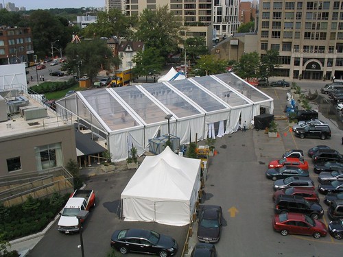
Photo (above): Tent erected for temporary club/dancehall for Toronto International Film Festival on future site of new Four Seasons Hotel at Bay St and Yorkville Ave. Night view (below).
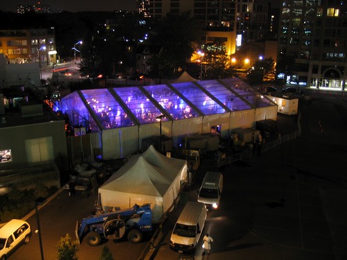
The flip-side of the Yorkville story is the (beastly?) craziness of the TIFF, this year neatly exemplified by the temporary tent/club/dancehall erected in the parking lot behind the sales centre for the new Four Seasons hotel and condo development at Bay St and Yorkville Ave. How this club (whose entrance seems to be through the sales centre) is related to the hotel and condos is perplexing at this point, but it has made for an interesting addition to the streetscape and nightscape – particularly the eeriness of the blue-purple pulsating lights and deep base emanating from the transparent roof of a party that would normally be wholly invisible to the outside world.

Photo: St. Thomas St, Yorkville
A second construction hoarding was erected on St. Thomas St south of Bloor recently, across the street from an existing hoarding (which has since been taken down). For a short time, the two facing hoardings protecting the sidewalks appeared to resemble a street lined with arcades, in its small spatial scale not unlike many you will see in southeast asia, such as this one in Singapore.

Photo: Street/lane in Singapore
This small scale of space is a relatively infrequent occurrence in Toronto, especially as part of a public street. While we’re used to such small scales in our back alleys, those alleys are, with but few exceptions, the city’s backdoors – infrequently travelled and largely empty, with few uses facing on to them other than the occasional residence and dominated by garages or blank walls and service entries. They do not really form a part of the public face of the city or city life.
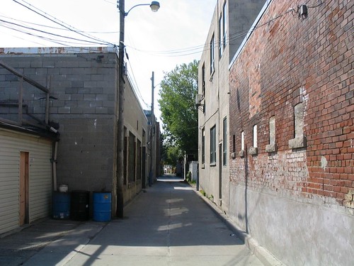
Photo: Laneway in the Junction
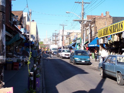
Photo: Kensington Market (photo by raptortheangel)
Somewhere approaching this scale of space that is part of the public face of the city is most famously exemplified by Kensington Market, where not only the buildings, produce and products are jostled up against the sidewalk, but the streets are narrow and bustling with people, and to add to the compression of space, filled with parked cars and delivery trucks and slowly crawling traffic. It all adds up to a very human (dare we say humane?) scale that somehow makes you feel comfortable, as though you’ve been enveloped in the city. In fact, Kensington moves beyond a sense of space, and somehow transcends that rather empty word, to have evolved a sense of place, one that is both undeniable and unique.
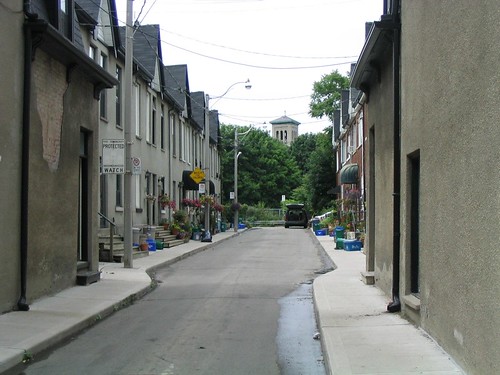
Photo: Wilkins Ave, off King St E, east of Parliament
There are a few other examples of small space in the city, but they tend to be rather hidden and brief moments – although that just makes them seem all the more jewel-like when you discover them.
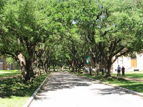
Photo: Tree-lined street at Rice University, Houston
While small space is not the only way to attempt to foster sense of place, I think that there is some connection between this sense of scale, sense of space and sense of place. Similar effects of scale can even be created by the canopies of closely-spaced street trees, as at Rice University (above), but can also be misguided in implementation as in this accident of line-of-sight where Casa Loma’s tower is perfectly framed by the laneway between Walmer Rd and Spadina Rd south of Davenport, which doesn’t so much benefit the laneway itself, but creates some sense of drama and intrigue for all those people walking along MacPherson Ave towards George Brown College.
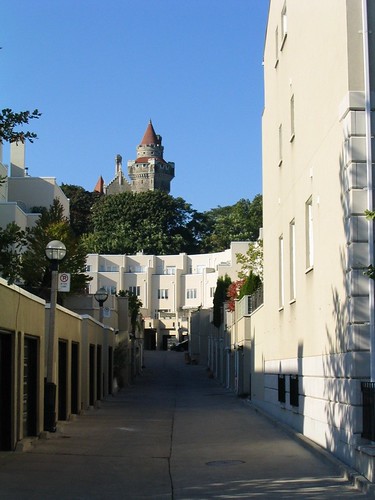
Photo: Looking towards Casa Loma up rear lane between Walmer Rd and Spadina Rd
Whether or not anyone agrees with me about the importance of small scale when it comes to sense of place, I think we can safely say that a key missing ingredient in the urbanities being created in suburban locales around Toronto (and the rest of north america) is the absence of small-scaled space. This absence has been compensated for in many different ways, but most notably (need I say, horrifically and ironically?) by the deliberately pedestrian scale of space of the “shopping street” inside the typical mall and, more recently, by the creation of “pedestrian-oriented” centres in suburban locales, usually surrounded by seas of parking and/or parking garages and huge arterial roads and/or expressways. These new “centres”, sometimes presumed to be the end of the mall (and often replacing them), are in reality the mall’s evolution into a more plausible (but still staged) “reality”, one that is once again based upon the smaller scale that has become nostalgically associated with our cities’ historic centres and main streets.
Whether this small scale can once again be more fully integrated into the urban environments we are building may depend on the level of commitment we as a society are willing to make to creating spaces and places planned and designed around people instead of cars. On this question the jury’s still out. Despite recent progress and a lot of talk to the contrary, the evidence on the ground does not convince.

An ongoing series of reflections on the city, the landscape and the fields that manipulate them from the perspective of urban design, landscape architecture, Toronto and Canada.
Posts RSS
PaD Shanghai Photos RSS
From the Vault Photos RSS
Documentation
Plugins
Suggest Ideas
Support Forum
Themes
WordPress Blog
WordPress Planet
